Windfall Run
| Windfall Run | |
|---|---|
 | |
| Physical characteristics | |
| Source | |
| • location | wetland on a plateau in Noxen Township, Wyoming County, Pennsylvania |
| • elevation | between 2,200 and 2,220 feet (671 and 677 m) |
| Mouth | |
• location | Baker Run in Noxen Township, Wyoming County, Pennsylvania |
• coordinates | 41°24′16″N 76°07′20″W / 41.40438°N 76.12233°W |
• elevation | 1,365 ft (416 m) |
| Length | 1.6 mi (2.6 km) |
Basin size | 1.68 sq mi (4.4 km2) |
| Basin features | |
| Progression | Baker Run → Bowman Creek → Susquehanna River → Chesapeake Bay |
Windfall Run is a tributary of Baker Run in Wyoming County, Pennsylvania, in the United States. It is approximately 1.6 miles (2.6 km) long and flows through Noxen Township.[1][2] The watershed of the stream has an area of 1.68 square miles (4.4 km2). The stream itself is classified as Class A Wild Trout Waters by the Pennsylvania Fish and Boat Commission. The surficial geology in its vicinity includes Wisconsinan Till and bedrock.
Course
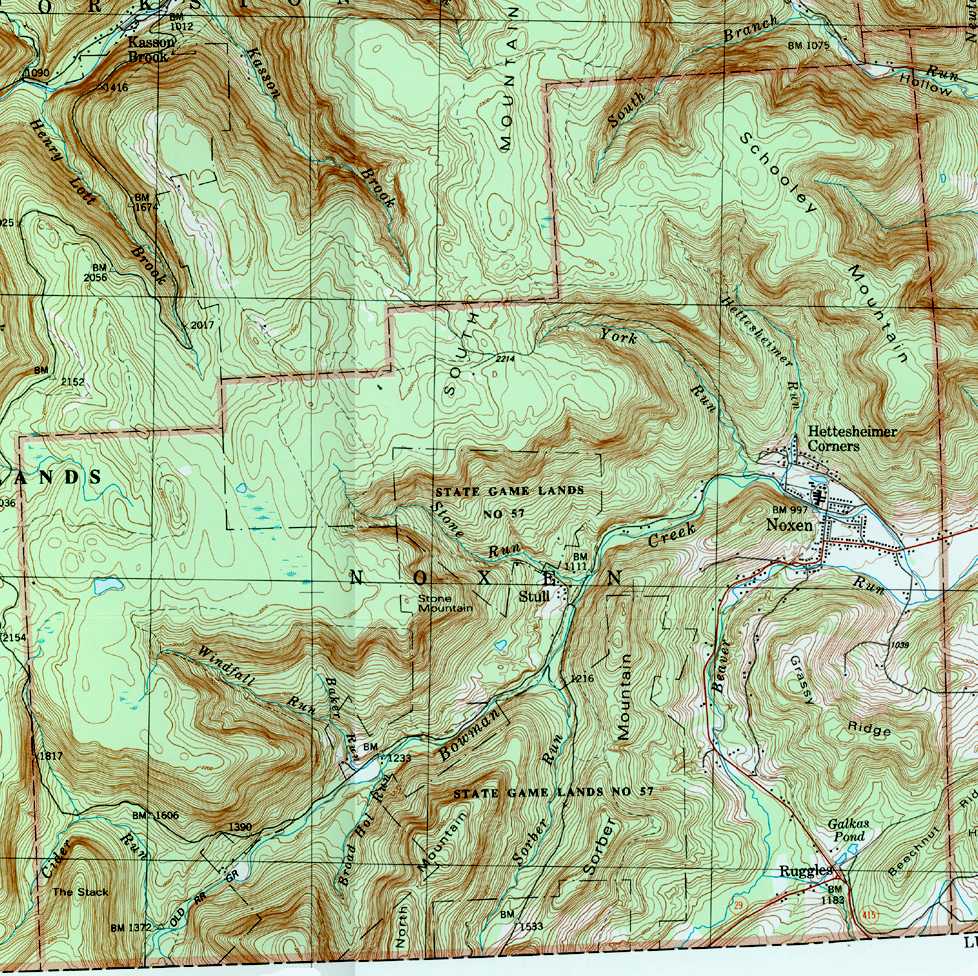
[edit]Windfall Run begins in a wetland on a plateau in Noxen Township. It flows north-northeast for several tenths of a mile and enters a deep valley before turning east-southeast. The stream flows in this direction for more than a mile before reaching its confluence with Baker Run.[1]
Windfall Run joins Baker Run, which is itself only 1.1 miles (1.8 km) long, 0.66 miles (1.06 km) upstream of its mouth.[1][3]
Hydrology
[edit]The concentration of alkalinity in Windfall Run is 4 milligrams per liter (0.0040 oz/cu ft).[4]
Geography and geology
[edit]The elevation near the mouth of Windfall Run is 1,365 feet (416 m) above sea level.[5] The elevation near the source of the stream is between 2,200 and 2,220 feet (671 and 677 m) above sea level.[1]
The surficial geology along Windfall Run in the Dutch Mountain quadrangle, where most of the stream is situated, consists of a till known as Wisconsinan Till. However, bedrock consisting of sandstone and shale occurs on the sides of the stream's valley.[6]
For much of its length, Noxen Township flows through a deep valley cut into a plateau.[7]
Watershed
[edit]The watershed of Windfall Run has an area of 1.68 square miles (4.4 km2).[3] The mouth of the stream is in the United States Geological Survey quadrangle of Noxen. However, its source is in the quadrangle of Dutch Mountain.[5]
The entire length of Windfall Run is on public land that is open to access.[4] The stream is situated entirely within Pennsylvania State Game Lands Number 57.[7]
History
[edit]Windfall Run was entered into the Geographic Names Information System on August 2, 1979. Its identifier in the Geographic Names Information System is 1199800.[5]
Biology
[edit]Wild trout naturally reproduce in Windfall Run from its headwaters downstream to its mouth.[2] The stream is designated by the Pennsylvania Fish and Boat Commission as Class A Wild Trout Waters for brook trout from its headwaters downstream to its mouth.[4]
See also
[edit]References
[edit]- 1 2 3 4 United States Geological Survey, The National Map Viewer, retrieved October 12, 2015
- 1 2 Pennsylvania Fish and Boat Commission (August 2015), Pennsylvania Wild Trout Waters (Natural Reproduction) – August 2015 (PDF), p. 106, retrieved October 12, 2015
- 1 2 Pennsylvania Gazetteer of Streams (PDF), November 2, 2001, p. 152, archived from the original (PDF) on September 17, 2015, retrieved October 12, 2015
- 1 2 3 Pennsylvania Fish and Boat Commission (August 2015), Class A Wild Trout Waters (PDF), p. 24, retrieved October 12, 2015
- 1 2 3 Geographic Names Information System, Feature Detail Report for: Windfall Run, retrieved October 12, 2015
- ↑ Duane D. Braun (2007), Surficial geology of the Dutch Mountain 7.5-minute quadrangle, Wyoming, Sullivan, and Luzerne Counties, Pennsylvania, p. 18, archived from the original on May 24, 2014, retrieved October 12, 2015
- 1 2 United States Geological Survey (1987), noxen.jpg, retrieved October 12, 2015