


Hicks Island
 Interactive map of Hicks Island | |
| Geography | |
|---|---|
| Location | Northern Australia |
| Coordinates | 11°58′59″S 143°16′08″E / 11.983°S 143.269°E |
| Area | 1.6 km2 (0.62 sq mi) |
| Administration | |
| State | Queensland |
Hicks Island is an island about 1 km southeast of Cape Grenville in the Great Barrier Reef Marine Park Queensland, Australia, in Temple Bay about 200 km northeast of Kutini-Payamu National Park and Lockhart River in the Cape York Peninsula.[1] It is around 160 hectares (395.4 acres) in size.[1] This island is part of the Home Islands group.
Birdlife
[edit]Hicks Island is part of the Cape York to Cape Grenville Islands Important Bird Area.[2] The island is inhabited by species such as the pied imperial-pigeon, bridled tern, roseate tern and lesser crested tern.
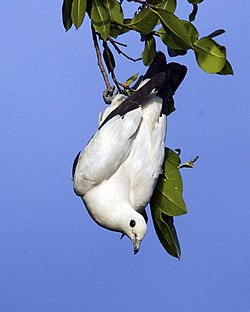 A pied imperial-pigeon
 A bridled tern pair
 A roseate tern pair


References
[edit]- 1 2 "Map of Hicks Island, QLD". Retrieved 10 January 2013.
- ↑ "Cape York to Cape Grenville Islands". BirdLife International. Retrieved 10 January 2013.
 | This Queensland protected areas related article is a stub. You can help Wikipedia by adding missing information. |