


Capps, Arkansas
Capps, Arkansas | |
|---|---|
  Capps, Arkansas Location within Arkansas  Capps, Arkansas Location within the United States | |
| Coordinates: 36°14′08″N 93°11′22″W / 36.23556°N 93.18944°W | |
| Country | United States |
| State | Arkansas |
| County | Boone |
| Elevation | 1,440 ft (440 m) |
| Time zone | UTC-6 (Central (CST)) |
| • Summer (DST) | UTC-5 (CDT) |
| Area code | 870 |
| GNIS feature ID | 57506[1] |
Capps is an unincorporated community in Boone County, Arkansas, United States. Capps is located on Arkansas Highway 392, 4.6 miles (7.4 km) west of Harrison.[2]
References
[edit]- ↑ "Capps". Geographic Names Information System. United States Geological Survey, United States Department of the Interior.
- ↑ Boone County, Arkansas General Highway Map (PDF) (Map). Arkansas State Highway and Transportation Department. 2002. Archived from the original (PDF) on July 18, 2011. Retrieved January 6, 2012.
Municipalities and communities of Boone County, Arkansas, United States | ||
|---|---|---|
| Cities | 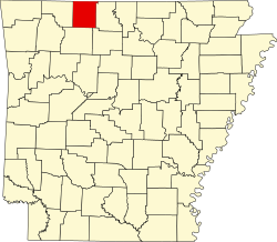 | |
| Towns | ||
| Townships | ||
| CDP | ||
| Other unincorporated communities | ||
| Ghost town | ||
| Footnotes | ‡This populated place also has portions in an adjacent county or counties | |
 | This article about a location in Boone County, Arkansas is a stub. You can help Wikipedia by adding missing information. |