Edge Rewrite
// HTMLRewriter · presentation

This page was redesigned at the edge.

Cloudflare fetched the original article and streamed it through HTMLRewriter to apply an entirely new visual system without rebuilding the source page.

// request.cf · coarse context

A page that knows where it met you.

Only coarse request metadata is shown. This demo does not display or persist visitor IP addresses.

Country
US
Cloudflare location
CMH
Connection
HTTP/2
Language
Not provided

Ray ID: a24638c0d89a5645

Jump to content

Wikipedia:Graphics Lab/Map workshop/Archive/Apr 2026

From Wikipedia, the free encyclopedia

Number of partners by country

It is for the page Body Count (sexual partners). Here is the reference Link TrueMoriarty Talk | Contribs 03:50, 27 February 2026 (UTC) WP:SOCKSTRIKE

Correction request for map of Tennessee State Route 155

Description of the image
Article(s)
Tennessee State Route 155
Request
This article is currently a good article nominee that is close to promotion. The map incorrectly shows a roadway called Woodmont Boulevard (located between US 70S and US 31) as part of SR 155, which it is sometimes mistaken as part of. I need this corrected. I would also like the map to be color coded to show the parts of SR 155 that are designated as Briley Parkway, Thompson Lane, and White Bridge Road. -- Bneu2013 (talk) 23:42, 5 April 2026 (UTC)
Discussion

2026 Strait of Hormuz crisis map

Article(s)
en:2026 Strait of Hormuz crisis
Request
With how notable this topic is, mapping the attacks conducted by Iran against vessels in the Strait of Hormuz would be quite valuable, akin to the Red Sea crisis map. I would try to do it myself but an svg of the strait is way too slow for Inkscape on my pc. As for sources, The Washington Institute has an map which is regularly updated, though I'm sure you can find similar maps from other reliable sources. -- Hsnkn (talk) 15:46, 7 April 2026 (UTC)
Discussion
https://www.washingtoninstitute.org/menamaritime/%7Cinteractive gives a 404. cmɢʟee τaʟκ (please add {{ping|cmglee}} to your reply)
@Cmglee: There's also a link on the announcement page. Hsnkn (talk) 17:04, 8 April 2026 (UTC)

Balkans gas transit: crop and correct

Article(s)
Balkan Stream
Request
This has come into the news recently https://www.dw.com/en/serbia-russian-gas-pipeline-explosives-sabotage-hungary-orban/a-76674841 and I have a little more info from when I requested in March last year at https://en.wikipedia.org/wiki/Wikipedia:Graphics_Lab/Map_workshop/Archive/Mar_2025#h-Balkans_gas_transit:_shrink_and_correct-20250224174600. I tried to use https://commons.wikimedia.org/wiki/Commons:SVG_Translate_tool to add English to this map but was unsuccessful - apparently the text is in pixels and it may be too big for the tool. I asked the original author for the source but no reply yet - the Bulgarian part may be the map on p74 (last page) of https://www.bulgartransgaz.bg/files/useruploads/files/amd/TYNDP%202020-2029%20EN.pdf The above DW news link says Balkan Stream goes to Hungary, but even though gas transits Hungary to Slovakia I can't find any source which says that transit is called "Balkan Stream" so please can you remove the section within Hungary.

I don't mind whether you keep original language or just use English as long as it works with SVG translate - you don't need to translate as we can do that. Please could you correct the coloring: from the map on page 14 of https://www.energy-community.org/dam/jcr:2d6dbbe2-97a7-4643-a187-b71c7e82f002/Improvement%20of%20the%20commercial%20attractiveness%20of%20the%20Trans-Balkan%20pipeline%20system%20-%20Analytical%20and%20Recommendations%20Report.pdf we know the Trans-Balkan pipeline (dark blue) goes all the way from Turkey to Ukraine.

Please crop the right hand side at a longitude around Odesa to remove Russian controlled areas such Crimea as they are distracting. The top could be cropped to just below the top of Romania and the left to just east of the westernmost part of Serbia. Don't think we need to name Greece so the scale could go there if you think looks good. Please name Black Sea.

Also it would be great if you could label Turkstream, Trans-Balkan pipeline and Balkan Stream next to the lines rather than as a legend.Chidgk1 (talk) 10:01, 8 April 2026 (UTC)

Discussion

Convert Map of the Americas (pre-1500) to SVG

Original PNG map showing the Americas before European contact.
Article(s)
Pre-Columbian era
Indigenous peoples of the Americas
History of the Americas
Request
Please convert this PNG map into a high-quality SVG format. The current version is pixelated when zoomed in and difficult to translate.
* Please use a standard SVG base map for geographical accuracy.
* Ensure that all text labels are converted to editable text objects rather than paths.
* Please try to maintain the existing color coding for the various regions/civilizations.
Thanks! -- Dixy52 (talk) 21:58, 8 April 2026 (UTC)
Discussion
It looks like a Robinson projection of the world with the eastern part cropped off – note how slanted Alaska looks. As such, it's likely not the best projection to show the Americas compared to one properly centered near Mexico. My 2p, cmɢʟee τaʟκ (please add {{ping|cmglee}} to your reply) 08:24, 9 April 2026 (UTC)
I didn't find any better maps on commons. Apparently, there aren't many svg maps of the americas directly centered on Mexico. I'll let you know if I find one! Dixy52 (talk) 09:47, 9 April 2026 (UTC)
Comment: I created and added new map projection
 Done I did the work myself

Ukraine gas transit: vectorise and simplify

Article(s)
Natural gas transmission system of Ukraine
Request
I think gas is likely to remain geopolitically important for some time but the article is still relying on my slapdash attempt from over a year ago. To make this map easier for readers to follow and for me to translate it would be great if you could

1) Crop off everything east of Kyiv

2) Remove all towns and cities except Kyiv, Odesa and Lviv

3) Remove Prypats River

4) Convert to svg

5) Add in small inconspicuous font: Source: tsoua.com/en/news/a-new-phase-of-the-vertical-corridor-initiative-to-launch-in-july-2024/

As well as the official source mentioned in 5) above there is also a map on page 3 of https://s3.eu-west-1.amazonaws.com/icis.ada.website.live/wp-content/uploads/2024/05/03170057/ICIS_VerticalCorridor_April2024.pdf If it is easier for you to simply draw a new one based on the source please do so. Or if you have other suggestions I will be happy to hear them.

Do you think this request should be combined with the one above?

Discussion

I tried to do this with Le Chat AI but it said "an error occured". Can you humans do better? Chidgk1 (talk) 11:23, 10 April 2026 (UTC)

Fish distribution map

I would be much obliged for a map that shows the distribution of Poecilia velifera, P. kykesis, P. mexicana, and P. orri in the Yucatan Peninsula. The map is for the article Poecilia velifera, which I intend to bring to FAR sometime this year. The source is Robert Miller's Freshwater fishes of México, which includes the following distribution maps:

This could be a maplink (such as this one at Poecilia vandepolli) or a simple map. Please let me know if you need anything else! Surtsicna (talk) 19:39, 23 March 2026 (UTC)

Alternative map

Alternatively, a map showing only the occurences of P. velifera on the Yucatan Peninsula along with an insert showing the places around the world where it has been introduced: Thailand (Chao Phraya River and in the Songkhla Lake basin), Peru (Department of Lima), Israel, Taiwan, Libya (Ain Zayanah lagoon), Singapore, Colombia, Brazil (Paraíba do Sul basin).

Whichever you find easier or more fun to make! Surtsicna (talk) 19:35, 12 April 2026 (UTC)

Request: Data version of Template:2026 Iran war map

Coming here to forward a request by @Inter-rede that I'm not well-versed enough to understand myself. The request is to upload the map from Template:2026 Iran war map to Commons in a manner along the lines of Data:Japan.map. (Clarifying questions should be addressed to them!) Placeholderer (talk) 14:26, 9 April 2026 (UTC)

I managed to upload it here and ask someone to review it.
Map
Map
Inter-rede (talk) 03:36, 16 April 2026 (UTC)

SC Heritage Corridor: Discovery Route map + SC Heritage Corridor: Nature Route map

Need these for a page I am making, refer to making the map from here. TopG741 (talk) 21:58, 25 April 2026 (UTC)

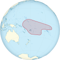
Tongan empire map update request

Update request
Article(s)
Tuʻi Tonga Empire
Request
The image before depicted the Tonga Empire as a behemoth the occupied almost all of the eastern pacific (https://upload.wikimedia.org/wikipedia/commons/b/bb/Map_of_the_of_Tu%27i_Tonga_Empire.svg) and it was changed to this newer and much more modest map (https://upload.wikimedia.org/wikipedia/commons/2/27/Tongan_Empire.png). However, the newer map is missing territories. The History of Tonga article states: "Their realm contained Wallis and Futuna, Tokelau, Tuvalu, Rotuma, Nauru, parts of Fiji, parts of the Solomon Islands, Kiribati, Niue, and parts of Samoa." Source provided is (https://books.google.com/books?id=0rE1vgAACAAJ)

Countries and places listed in the article that the map DOES contain: Samoa, Niue, Wallis and Futuna.

Countries and places listed in the article that the map DOES NOT contain: Tuvalu, Rotuma (part of Fiji), Nauru, Tokelau, parts of Kiribati.

I do not know how to make wikipedia maps. If there is any user here, of if the user who made the current map can update and add these territories, it would match the information on the history page and be historically accurate. -- ~2026-25870-40 (talk) 23:23, 29 April 2026 (UTC)

Discussion