This article is written in British English, which has its own spelling conventions (colour, travelled, centre, defence, artefact, analyse) and some terms may be different or absent from other varieties of English. According to the relevant style guide, this should not be changed without broad consensus.
This article is within the scope of WikiProject Greece, a collaborative effort to improve the coverage of Greek history on Wikipedia. If you would like to participate, please visit the project page, where you can join the discussion and see a list of open tasks.GreeceWikipedia:WikiProject GreeceTemplate:WikiProject GreeceGreece
This article is within the scope of WikiProject European Union, a collaborative effort to improve the coverage of the European Union on Wikipedia. If you would like to participate, please visit the project page, where you can join the discussion and see a list of open tasks.European UnionWikipedia:WikiProject European UnionTemplate:WikiProject European UnionEuropean Union
This article is within the scope of WikiProject Countries, a collaborative effort to improve the coverage of countries on Wikipedia. If you would like to participate, please visit the project page, where you can join the discussion and see a list of open tasks.CountriesWikipedia:WikiProject CountriesTemplate:WikiProject Countriescountry
This article is substantially duplicated in one or more external publications. Since these publication(s) copied Wikipedia, rather than the reverse, please do not flag this article as a copyright violation of the following source:
Latest comment: 2 months ago1 comment1 person in discussion
Just so you guys know, Mount Olympus has been added to the list of UNESCO World Heritage sites, bringing the total number in Greece to 21. Need to update any info in the article relevant to this subject pls. Thanks ~2026-41663-96 (talk) 03:03, 27 July 2026 (UTC)Reply
Removing the File:Greek Colonization Archaic Period.svg map
Latest comment: 1 month ago67 comments8 people in discussion
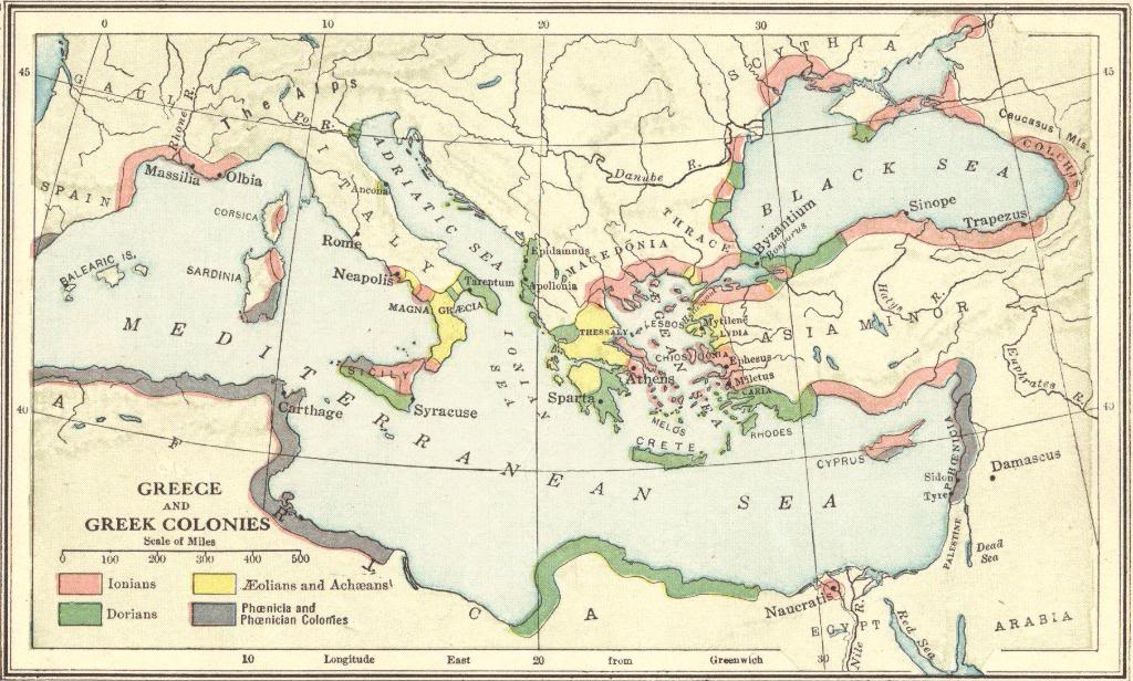
I suggest removing the File:Greek Colonization Archaic Period.svg map in Ancient Greece section because grossly misrepresents the Archaic Greek colonies. source:https://archive.org/details/isbn_9780723003045/page/74/mode/2up. Note the original map, which has a thin green line of maybe 10 km in northern Turkey and almost no thickness in southern Turkey, while the new map has a thickness of 70–100 km. The same applies to Egypt, southern Italy, Albania, Spain, and France. Also, the areas of Epirus (150km were added), Macedonia (150km were added) and Thrace are included in the new map. Cyprus is presented as totally Greek. BreadAndHumus (talk) 08:09, 2 August 2026 (UTC)Reply
I don't have access to the map in the book source, but I can find something quite similar also in other historical atlases, e.g. a Dumonts Atlas der Weltgeschichte I happen to have here. It looks pretty similar. Is there any sign that the thickness of these coastal stripes in either the source maps or our map is even meant to be significant? I think it is understood that these colonies weren't actually extensive areas but in reality punctual (individual cities, with very little hinterland each), and virtually all of them were directly on the coast, so the device of showing their overal area as contiguous stripes is a visual simplification in any case, and their thickness is not much more than graphic design choice? Fut.Perf.☼09:02, 2 August 2026 (UTC)Reply
Per Future Perfect's response, the map (as well as every other modern map) is an approximate illustration of the areas that Greek colonies were established. In fact, besides some major colonies, the vast majority of Greek colonies remain unnamed in this map. Their presence is implied inside the red areas. It also doesn't mean that all of these areas are entirely or majority Greek; it merely indicates the furthest extent of some prominent Greek presence, ie colonies which were in communication with each other; it is not meant to have much more significance than that. Just a few examples, in Greek Colonisation: An Account of Greek Colonies and Other Settlements Overseas one can see much more colonies, which in this map are absent, e.g. in p.2 the colonies in Macedonia and Thrace, p.156 the colonies in the Adriatic Sea, in p.188 the ones in Libya etc. In A Small Greek World: Networks in the Ancient Mediterranean p.67 and in Settlements and Necropoleis of the Black Sea and Its Hinterland in Antiquity p.2 we see much more colonies in the Black Sea. Piccco (talk) 10:35, 2 August 2026 (UTC)Reply
I agree with Piccco and Future Perfect at Sunrise. I looked at [:https://archive.org/details/isbn_9780723003045/page/74/mode/2up the map on Internet Archives]. There are four maps, three of which focus on Greece. The forth one encompasses the whole Mediterranean Sea with the location of numerous colonies (much more that the figure in question). The highlight color might be slightly more confined to the coast, i.e., it is not as thick, but we are talking about a few pixels, but these maps are difficult to read because of this reason. Nevertheless, such a thicker highlighting is necessary to help the reader, e.g., the size of the cities are not as big as the circles used in the map. However, the highlighting of the original figure is consistent with other maps, e.g., and . For example, both of these maps highlight southern Turkey as in the original. These two maps have been added as sources to the figure in question in WikiCommons.
Finally, accusing "gaslighting tactics – such as history re-writing, reality denial, misdirection" other editors is insulting when you have no evidence, and one has to ask this about BreadAndHumus, given the pattern of behavior ever since the creation of this account (nearly all the edits have been reverted). Moreover you raised the same issue in Talk:Archaic_Greece#Removing_the_File:Greek_Colonization_Archaic_Period.svg_map, which constitute a violation of WP policies per WP:FORUMSHOP. Please comply with WP policies. A.Cython(talk)17:08, 2 August 2026 (UTC)Reply
The maps you've provided are for high schools from 1890 and you cannot reference them here. You are insisting that the current map is fine. None of the three sources provided none shows a 70–100 km deep strip in northern and southern Anatolia, none includes Epirus and Macedonia, and none depicts such deep penetration into Africa, Italy, France, and Spain. The refusal to acknowledge the gross misrepresentation of the map and to remove it speaks volumes. BreadAndHumus (talk) 17:53, 2 August 2026 (UTC)Reply
You have been systematically trying to rewrite history here in elsewhere and at every stage you deny reality even numerous other editors disagree with you, e.g., Talk:Byzantine_Empire#Responses. We are all volunteers and we do not enjoy arguing over no burger issues. Your national sensitivities (as it becomes apparent) are irrelevant to any discussion. I remind you that there is a track record of your WP:NOTHERE actions and statements. So please start to comply with WP policies and use your energies into a more constructive attitude. Thank you. A.Cython(talk)18:50, 2 August 2026 (UTC)Reply
none includes Epirus and Macedonia The source map shows colonisation all along the coasts of both Epirus and Macedonia. You are correct that our map shows a thicker coastline, but like Future Perfect and A.Cython this strikes me as an acceptable design choice allowing for legibility at the much smaller size Wikipedia's images are displayed. Caeciliusinhorto-public (talk) 08:48, 3 August 2026 (UTC)Reply
Besides that, I will just add that I also provided sources that showcase the number of colonies in some of these areas individually. Additionally, the south of Italy is well-known for its large number of Greek colonies , to the point that it was referred to as Magna Graecia. Piccco (talk) 10:26, 3 August 2026 (UTC)Reply
Someone could interpret this map as connected to the Megali Idea. It looks very similar (especially in the areas covering Turkey, Cyprus, and the Balkans) to this map . By grossly exaggerating the area of ancient colonies (adding 100–150 km), someone could be trying to legitimize irredentist claims. Here is another similar map BreadAndHumus (talk) 12:15, 3 August 2026 (UTC)Reply
Megali idea is dead for over a century due to the exchange of population between the two countries in 1922. The maps you presented are irrelevant. So this someone could be trying to legitimize irredentist claims is just getting out of hand. A.Cython(talk)13:10, 3 August 2026 (UTC)Reply
It looks very similar (especially in the areas covering Turkey, Cyprus, and the Balkans) to this map It doesn't look that similar. That map covers much more of inland Turkey but doesn't extend anywhere near as far around the Turkish coast, and similarly goes much further inland in the Balkans; on the other hand the archaic Greece map covers a bunch of places which had absolutely no connection to the Megali idea (the coast of Albania and Croatia, southern Italy and Sicily, the mediterranean coast of France, the coast of Egypt/Libya). And if that's not clear enough, the caption is explicit.
I struggle to believe that anyone could in good faith misinterpret this map as being about the Megali idea. We can always make up a hypothetical person who might misinterpret anything written on wikipedia in some wild way, but without evidence that these people exist we can't possibly go around tying ourselves in knots to prevent them. There will always be another hypothetical bad faith misinterpretation. Caeciliusinhorto-public (talk) 13:36, 3 August 2026 (UTC)Reply
You're arguing that we should keep a map that grossly exaggerates the areas of colonization and adds an extra 70–150 km. This map misrepresents historical reality. The refusal to remove it and replace it with an accurate one speaks volumes, especially in an article with many visitors. Someone could reasonably deduce that the combination of this misrepresentation, the refusal to correct the mistake, and the map’s inclusion in a high-traffic article points to an underlying objective. Why don’t you want to replace it with an accurate one? BreadAndHumus (talk) 14:12, 3 August 2026 (UTC)Reply
Why don’t you want to replace it with an accurate one? I would be very happy to see a more accurate map. I don't see that one has been suggested. I would oppose removing a sufficiently accurate map without any replacement. Caeciliusinhorto (talk) 17:19, 3 August 2026 (UTC)Reply
Besides the mere insanity of this claim, I find the misdirection of the present discussion about an ancient map to such topics, and the obvious implications made above, very problematic. Piccco (talk) 14:14, 3 August 2026 (UTC)Reply
Nobody above has discussed replacing the map with another; what you proposed doing was simple to remove it. You brought up the notion of "replacing" it only in your second-to-latest posting, an hour ago. Have we got a more accurate map? If not, of course, feel free to make one. -- Fut.Perf.☼15:34, 3 August 2026 (UTC)Reply
Something tells me that the accurate rendition of the map will cause an uproar. There is no way you will let me post this map in the article for Greece. Let’s see if I’m correct or not. Give me 48 hours. BreadAndHumus (talk) 16:47, 3 August 2026 (UTC)Reply
Do not violate WP policies, the proposed map has issues that need to be addressed before replacing previous accepted version. The attitude of violate rules and then play the victim by blaming everyone else is concerning.
BTW how exactly is your map more accurate when maps from WP:RS sources you thicker lines, e.g., ? I was barely able to notice these lines. Call me blind or something, but many readers might have sight problems. A thicker line is there to preserve the historical accuracy and accessibility. Such thin lines appear WP:OR to satisfy national sensitivities (after the user's admission of imaginary concerns of Megali Idea). Oh and you eliminated any indications of Greek colonies in south of Turkey, how is this more accurate? A.Cython(talk)15:45, 4 August 2026 (UTC)Reply
The map accurately represents the source file. The colonies in my map are a copy of the older map that you defend. You're just finding excuses to argue endlessly. This is clear case of WP:OWN and WP:STONEWALL BreadAndHumus (talk) 16:03, 4 August 2026 (UTC)Reply
User:BreadAndHumus, thanks for this effort at providing a new map. That's a good start. I think I said above that I don't consider the previous map wrong in any serious way, but I don't mind considering your alternative at all. So, the main difference is that you are now making a systematic visual differenciation between areas where Greek settlement is seemingly constrained to the coast (indicated by a uniformly narrow red stripe along the coast), and areas where it penetrates more inland (indicated by solid red areas). Do we agree that such a distinction makes sense? Like, on the European side of the Bosporus we have Greek colonies only on the coast, but on the opposite side in Bithynia we have a full area of inland settlement? Same in Magna Graecia: only narrow coastal settlements in Sicily and Salento, but full-area settlement across Calabria. Is this what you intended to show, and are we sure your source map meant to make such a distinction?
A few nitpicks: (a) "Cilicia" is misspelled "Cylicia". (b) "Colony" is misspelled "Collony". (c) I'm not sure what those small overlapping lines around the mouth of the Dnieper are meant to be – Greek colonies on the Kinburn spit? (d) No Greek colonies on Thasos?
The source map that you claim it is based has the Ionian colonies all along the southern coastal Turkey, e.g., Side, Coracesium, Nagidus, Celenderis, Soli, Mallus. These colonies are on the source map... there is one more not on the coast, i.e., mainland colony of Aspendus, see location. Yet you included Tarsus which is not in the source map. So I am going to ask again how is the proposed map more accurate when you deliberly exclude information from the source map and in complete disagreement with other maps but at the same time insert irrelevant information that helps pushing a nationalist agenda? A.Cython(talk)17:12, 4 August 2026 (UTC)Reply
Well, for Epirus we'd presumably have to distinguish the indigenous tribal Greek groups from the Greek colonies that were founded along their coast, like Ambracia – in this map that is focused on the latter, I'd find it justifiable to omit the former, just as it's not showing anthing in Macedonia either. If that's what the source map does, that's fine with me. Fut.Perf. ☼ 17:35, 4 August 2026 (UTC)
I agree with this approach. By the way (in case you do not have access to the source map), the source makes a clear distinction between two separate parts: "Extent of Greece in 750 BC", which would now correspond with the solid red areas, and "coast under Greek influence (approximate)", which corresponds to the thin red coastal strips. This is also probably why Epirus and Macedonia are by this time not yet included in the main shaded area. I would recommend preserving this distinction with corresponding labels by maybe using two different colors. The actual source does not, for instance, mention "areas of Greek settlement."Nishjan (talk) 18:48, 4 August 2026 (UTC)Reply
Would it also be possible to remove the red coastline of Apulia (Messapia) on the Adriatic? That section was not colonized, and is not included in the source map. Nishjan (talk) 17:21, 4 August 2026 (UTC)Reply
Nishjan While the source map goes up to Edidamnus other maps as the ones presented above do include areas in the north of Andratic Sea. So removal is not justified, given that these maps have been added as sources. A.Cython(talk)17:36, 4 August 2026 (UTC)Reply
Could you link the map you are taking about? Because most of the maps I see here are, to put it mildly, rather outdated. Furthermore, I'm not aware of any Greek colonies in this part of Apulia, so I'm curious which source it is based on. Nishjan (talk) 17:48, 4 August 2026 (UTC)Reply
Epidaurum founded in sixth century BC though we do not know exact date so it could be older. There is scholarship that places the founding in the archaic period. I will provide sources later as I am at work. A.Cython(talk)18:05, 4 August 2026 (UTC)Reply
a),b) will be fixed. c) no comment, d) the map you're defending now doesn't have a colony in Thasos. I've only put the colonies this map had. We can put a colony on Thasos but the color will remain non Greek. BreadAndHumus (talk) 17:32, 4 August 2026 (UTC)Reply
the other one is not even peerreviewed as it based popular atlas that does not specialize in the period, relevance is important. Also Age does not matter in a field that is relevant stable. A.Cython(talk)17:48, 4 August 2026 (UTC)Reply
Here is the improved version. Typo fixed and Apulia removed
That's not a fair statement, it is in fact already better, but it could benefit from additional modifications per the source. Nishjan (talk) 18:22, 4 August 2026 (UTC)Reply
No WP:OR does not make it better. I already mentioned that in the main source there are half a dozen cities in south of Turkey that are removed. The lines are barely visible and it is generally inconsistent with academic literature. A.Cython(talk)18:35, 4 August 2026 (UTC)Reply
Something tells me that the accurate rendition of the map will cause an uproar. There is no way you will let me post this map in the article for Greece. Let’s see if I’m correct or not.
If it is wrong then it is wrong. You still have not provided evidence that this an accurate map. There are far too many inconsistencies with the source map and with literature. A.Cython(talk)18:38, 4 August 2026 (UTC)Reply
The old map, the one that you’re defending, doesn’t have any of these colonies. In the new map, I just added whatever colonies the old map has, plus a couple of new ones. BreadAndHumus (talk) 18:50, 4 August 2026 (UTC)Reply
The old map has a highlight of where Greek colonies existed, which is consistent with the source map and other maps. Picking and choosing without a solid academic points of references is WP:OR as you just admitted. A.Cython(talk)18:57, 4 August 2026 (UTC)Reply
The whole purpose of this discussion is to correct the current map, which claims to be based on the source but does not accurately follow it. Furthermore, as other users have already pointed out, the colonies functioned as independent city-states. The Greeks never controlled the coastal regions that are shaded on the current map. This distinction should be clearly stated, especially since several existing maps on Wiki already create this same error, and will need fixing. Personally, I do not support using broad colored areas to represent the colonies, as this is historically inaccurate. However, if this map with shaded regions is retained, it should at least follow the current source it claims to be based on. In my view, there is already a better existing map that presents the situation way more accurately and clearly, without using controversial shading: More accurate map of the actual situationNishjan (talk) 19:14, 4 August 2026 (UTC)Reply
There were no issues and it has been stable for a long time. The map of what you are presenting is very difficult to read without zooming in and still it is a pain to read anything. I do not understand what Greeks controlled mean. This is a very anachronistic description. These were Greek colonies and operated as city states with some degree of dependence with the mother city. This broad colored areas to represent the colonies, as this is historically inaccurate is also a problematic statement. The map is very consistent with other maps of its kind used in academia. So what are you saying it is preferable to use WP:OR? We have other maps . I try to see more modern academic maps say though i doubt I can upload them due to copyright. A.Cython(talk)19:24, 4 August 2026 (UTC)Reply
That is simply not correct. The current map is WP:OR, not the one being proposed, which is clearly a better representation of the source; albeit additional corrections are still needed. You really need to familiarize yourself with WP:RELIABLE, as the century old maps you proposed cannot be seriously used, and it is frankly ludicrous to even suggest them. Btw, you are casting aspersions, as I have clearly stated multiple times that the map should be based on the actual source it claims to represent. If you do not understand what "Greek control of a territory" means, and cannot zoom a simple image, then there is really no reason to continue talking with you or to take any of your arguments seriously. Nishjan (talk) 19:59, 4 August 2026 (UTC)Reply
Not exactly. The purpose of this discussion is mainly the current map which grossly misrepresents the area of Greek penetration. The map is very similar to the ones used in Megali Idea. The editors have refused to delete the map stating that is good. When a new much improved map was presented the editors were just finding excuses not to use it. The map you're presenting is very good but it cannot be used because doesn't have a source. BreadAndHumus (talk) 19:29, 4 August 2026 (UTC)Reply
The new proposed map is WP:OR plain and simple by omitting half a dozen Greek colonies explicitly mentioned in the source map. Note that additional maps have been added in the source so you have to comply with those too. The whole thing of Megali Idea is ludicrous as others have told you. A.Cython(talk)19:34, 4 August 2026 (UTC)Reply
I also note that some users seem to be ignorant of the fact that Greek colonies has a peraea, which included the surrounding area and in some cases could be quite large. Thus, insisting on only showing the cities (which is already impossible due to their sheer number and the scale of the map), is also incorrect, and the approach of the current map in the article is more correct. The whole "Megali Idea" canard is impossible to take seriously (Megali Idea includes parts of Spain and France now?) and makes it increasingly hard to assume good faith. Khirurg (talk) 20:20, 4 August 2026 (UTC)Reply
I went through the edit history and found that you’ve injected the map into the article. Did you not check the source to see whether it corresponds with the map? The map is grossly distorted. I was also reading about Chrysi Avgi and the Megali Idea. I hope no one here has any connection with this criminal neo-Nazi organization responsible for the murders of Pavlos Fyssas and Murder of Shahzad Luqman, although this would explain many things. BreadAndHumus (talk) 20:56, 4 August 2026 (UTC)Reply
The map-scale issue is really important here. At the scale of the map, a dot already represents for the majority of the cases, both the colony and the associated area of settlement/influence, because the actual territorial extent of most colonial hinterlands would be too small to draw meaningfully. Nowhere would the current coastal shadings on the current map be representative of the actual size of the majority of these hinterlands, not even close. Nishjan (talk) 21:23, 4 August 2026 (UTC)Reply
Both Calabria and Bithynia are part of the coastal regions indicated in the source map, not part of the solid red area. The coastal region on the Adriatic part of Apulia should also slightly be corrected to stop at Otranto. Nishjan (talk) 19:30, 4 August 2026 (UTC)Reply
Speaking again of the File:Griechischen und phönizischen Kolonien.jpg map alternative Nishjan brought up above, I actually like the idea of just showing the colonies as individual dots as done there. There are two potential problems with that map: first, it isn't formally sourced. But I don't think that's really that much of a problem in this case, because the existence and location of each city is easily verifiable independently, and their overall distribution pattern is well aligned with all the other maps we've seen (remember that none of them have significant differences in that respect, beyond adding or omitting some tiny specks here or there, at a level of granularity none of them is really designed to be taken as gospel truth over). The second problem: it's just not easily readable. We should have a version with most of the tiny name labels and the coloured geographical relief background omitted, so that we'd be left with a pattern of dots, whose density across different areas would still be a good visual indicator of the intensity of Greek colonization in each area, together forming something quite analogous to the colorized areas we have in the other maps now but without making any unintended implications about geographical depth of penetration into the hinterland. Fut.Perf.☼07:42, 5 August 2026 (UTC)Reply
Yes, I would get behind this as a way forward. Even on my desktop monitor, the labels are only barely legible to me displaying the map at full-screen; on mobile (which makes up an increasing proportion of web traffic) it's totally illegible. If all we are using the map for here (and on Archaic Greece, where BreadAndHumus has also challenged it) is to demonstrate how widely dispersed archaic Greek colonisation was, I don't see the need for most of the labels anyway. Caeciliusinhorto-public (talk) 09:15, 5 August 2026 (UTC)Reply
The map mentioned by Future contains colonies founded in the classical era as well. We need to restric ourselves to Archaic era.
Regarding sourcing. Do we know any WP:RS that contains such a map? From a look that I made yesterday I found a couple of maps from modern sources but each provided a selection of colonies and some even included colonies such as Al Mina in Syria and Spina in Po Valley. This of course creates the immediate problems of using separate sources to construct the map (WP:SYTH comes to mind) and multiplies future points of conflicts for individual colonies.
The issue of accessibility would remain even if we have a dense network of these colonies because of the need to name each one of them. That is a basic requirement in map construction i.e., every symbol explained and named. Random dots on a map is a disservice to the reader. If one wants simplification then highlighting serves this purpose. We do this in other pages like Roman Empire, which was more of a collection of city states than the anachronistic empire description. Are we going to change these maps as well for the sake of accuracy?
The issue of accessibility would remain even if we have a dense network of these colonies because of the need to name each one of them I don't see that we do need to name each one. The previous map marks several areas of Greek settlement without naming a single one of the individual settlements (e.g. on the north coast of Sardinia, Crete, Cyprus, several stretches of the Black Sea coast). Why is the status quo of unlabelled areas marked on a map acceptable but unlabelled individual settlements would be doing the reader a disservice?
I would agree that if we want to replace the current map, which shows colonisation specifically in the archaic period, it would be preferable to have a map which is restricted to the same period. Caeciliusinhorto (talk) 18:53, 5 August 2026 (UTC)Reply
The difference is that unlabeled dots can be easily confused as geographical features or not been noticeable enough by the reader, effectively creating a misleading and innacurate picture. This is a sub standard practice of map making and avoided altogether in academia. Highlighting is used in academia to avoid the issues of dot clustering on maps. What you effectively proposing is to replace a decent figure with one with substandard academic mapmaking features to please national sensitivities an editor. This creates a very bad precedent and invites future aggression. If ain't broken don't fix it. We have so many other things to improve, this ain't one of them. Only when there is an obvious room for improvement in academic accuracy and accessibility we should venture into a quest for replacement. At this point no such argument or evidence have been presented to satisfy any of these two. By the way if we do this then shouldn't we also replace the maps of the Roman Empire as well? Or are we going to have two different standards? Perseption does matter in contentious topics, so let's not take actions that invite further issues. Happy editing. A.Cython(talk)19:21, 5 August 2026 (UTC)Reply
This is a sub standard practice of map making and avoided altogether in academia. It's the way the maps depicting archaic Greek colonisation in e.g. The Cambridge Ancient History do it. If we want to stick to best academic practices, we certainly shouldn't be using a map based on the Times Atlas of World History, as the current one is! Caeciliusinhorto (talk) 20:07, 5 August 2026 (UTC)Reply
Well both Cambridge (if what you said is true it shows of its quality) and Times Atlas are definitely not ideal choices. Though I doubt that they did not labeled any of the dots on the map.
The current map does not exclusively depends one source and it is consistent with other academic maps of its kind as I have said several times already. So yeah it is good enough. It is rather unclear to me why you pursue a replacement when we have not even established better sources than the already used. Aesthetics is very bad reason to initiate changes.
And we already have a map as you described Greek and Phoenician colonies about 550 BC except that its creator thought necessary to include highlight as it appears to be necessary, though this one also lacks sourcing.
I would prefer Oxford University Press as they have decent reputation on Classics (not that they also have lowered their quality in recent years in favor of more sales), see The Oxford encyclopedia of ancient Greece and Rome (2010) volume II at page 255 (where every dot is labeled, note that it has several volumes stack into one so there are several pages of 255), where they present a subset of representative colonies such as Al Mina in the east to Mainace in the west, both of which are missing in the current version of the map and in the other ones. If you are seeking accuracy then it better incorporate these colonies as well since they are presented in a modern WP:RS. The Oxford map does not include any colonies in Cyprus which is a serious omission, meaning that we need to depend on another map to fill the gaps. For anyone interested, see Greek colonisation volumes I and II is a good reference point.
So to reiterate my point. The current map may not be perfect but it is good enough as it is accurate enough and easily readable without zooming in, but if you are seeking to replace it, well it better be a clear improvement of the current version in both accuracy and accessibility. I am not saying that's impossible but this would require enormous amount of work to get this right, especially without highlighting. It needs to be readable without zooming in. If there is a brave soul to do this then that's fantastic, however, compromise one over the other will get a solid no from me. A.Cython(talk)21:50, 5 August 2026 (UTC)Reply
This is quite a good compromise, and I also agree with Caeciliusinhorto-public's reasoning about the labeling. @Future Perfect at Sunrise, since you already have quite the experience making maps on this topic, and that BreadandHumus is probably not the best person for the task anymore, would you be willing to make the map? Of course, only if time permits. Nishjan (talk) 16:11, 5 August 2026 (UTC)Reply


 level-4 vital article is rated B-class on Wikipedia's content assessment scale.


_(14763192482).jpg)