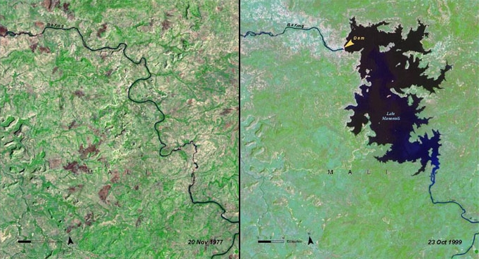
Lake Manantali
| Lake Manantali | |
|---|---|
 View from space. The Manantali Dam is at the top left corner of the lake, with the Bafing River running towards Senegal to the northwest. The river continues directly south. | |
  Lake Manantali Location within Mali | |
| Coordinates | 13°09′29″N 10°20′38″W / 13.158°N 10.344°W |
| Type | artificial |
| Bafing River | |
| Bafing River | |
| Basin countries | Mali |
Surface area | 477 km2 (184 sq mi) |
Water volume | 11.3 billion cubic metres (9.2×10⁶ acre⋅ft) |
| Settlements | Manantali, Tondidji |
Lake Manantali is a large artificial lake, formed by the 1989 construction of the Manantali Dam, on the Bafing River in Mali. Its northern point is located 90 km to the south-east of the city of Bafoulabé.

Size
[edit]Lake Manantali covers 477 km2 and contains 11.3 billion m3 of water. Its formation forced 12,000 people from their homes and flooded 120 km2 of forest. The lake largely ended the flood patterns on both the Bafing and Senegal Rivers, compromising traditional agriculture which depended upon seasonal flooding. The lake has created benefits as well: consistent navigation downstream of the dam, irrigation of surrounding land, and a source for commercial fishing. The dam itself provides hydroelectric power through much of the region.[1]
References
[edit]- ↑ Peter Bosshard. A Case Study on the Manantali Dam Project (Mali, Mauritania, Senegal), Erklärung von Bern/internationalrivers. March 1, 1999
- Knaap, M. van der. Status of fish stocks and fisheries of thirteen medium-sized African reservoirs. CIFA Technical Paper. No. 26. Rome, FAO. 1994. 107p.
- William R. Jobin (1999). Dams and Disease: Ecological Design and Health Impacts of Large Dams, Canals, and Irrigation Systems. Taylor & Francis. ISBN 0419223606.