Zibda
Zibda | |
|---|---|
| Arabic transcription(s) | |
| • Arabic | زبده |
  Zibda Location of Zibda within Palestine | |
| Coordinates: 32°27′00″N 35°07′45″E / 32.45000°N 35.12917°E | |
| Palestine grid | 162/206 |
| State | State of Palestine |
| Governorate | Jenin |
| Government | |
| • Type | Village council |
| Population (2017)[1] | |
• Total | 1,251 |
| Name meaning | Zebdah, Zebdah, personal name[2] |
Zibda (Arabic: زبده) is a Palestinian village in the Jenin Governorate.
History
[edit]Pottery sherds from the early and late Roman eras (20% + 25%),[3] Byzantine era (25%),[3][4] and early Muslim (10%) and the Middle Ages (15%) have been found here.[3]
Zibda is possibly the place called Zebedellum in Crusader sources in the year 1200.[3]
Ottoman era
[edit]Zibda, like the rest of Palestine, was incorporated into the Ottoman Empire in 1517. During the 16th and 17th centuries, Musmus belonged to Turabay Emirate (1517-1683), which encompassed also the Jezreel Valley, Haifa, Jenin, Beit She'an Valley, northern Jabal Nablus, Bilad al-Ruha/Ramot Menashe, and the northern part of the Sharon plain.[5][6]
In the census of 1596, the village appeared as Zabda, located in the nahiya of Sha'ara in the liwa of Lajjun. It had a population of 26 households, all Muslim. They paid a fixes tax rate of 25% on agricultural products, including wheat, barley, summer crops, goats and beehives, in addition to occasional revenues and a tax on a press for olive oil or grape syrup; a total of 6,500 akçe.[7] Pottery remains from the early Ottoman era (5%) have also been found here.[3]
Zibda was temporarily abandoned sometime after the 18th century due to war or blood feud between brothers, possibly during the Qays–Yaman war of 1840–1860.[8]
In 1838 Zebda was noted as a village in the Jenin province, also called the Haritheh esh-Shemaliyeh province.[9]
In 1870/1871 (1288 AH), an Ottoman census listed the village in the nahiya of Shafa al-Gharby.[10]
In 1882, the PEF's published its 1870s Survey of Western Palestine (SWP) described Zebdah as "a ruined village with a well."[11]
British Mandate era
[edit]In the 1922 census of Palestine conducted by the British Mandate authorities, Zabdah had a population 150 Muslims,[12] decreasing in the 1931 census to 132 Muslim, in a total of 22 houses.[13]
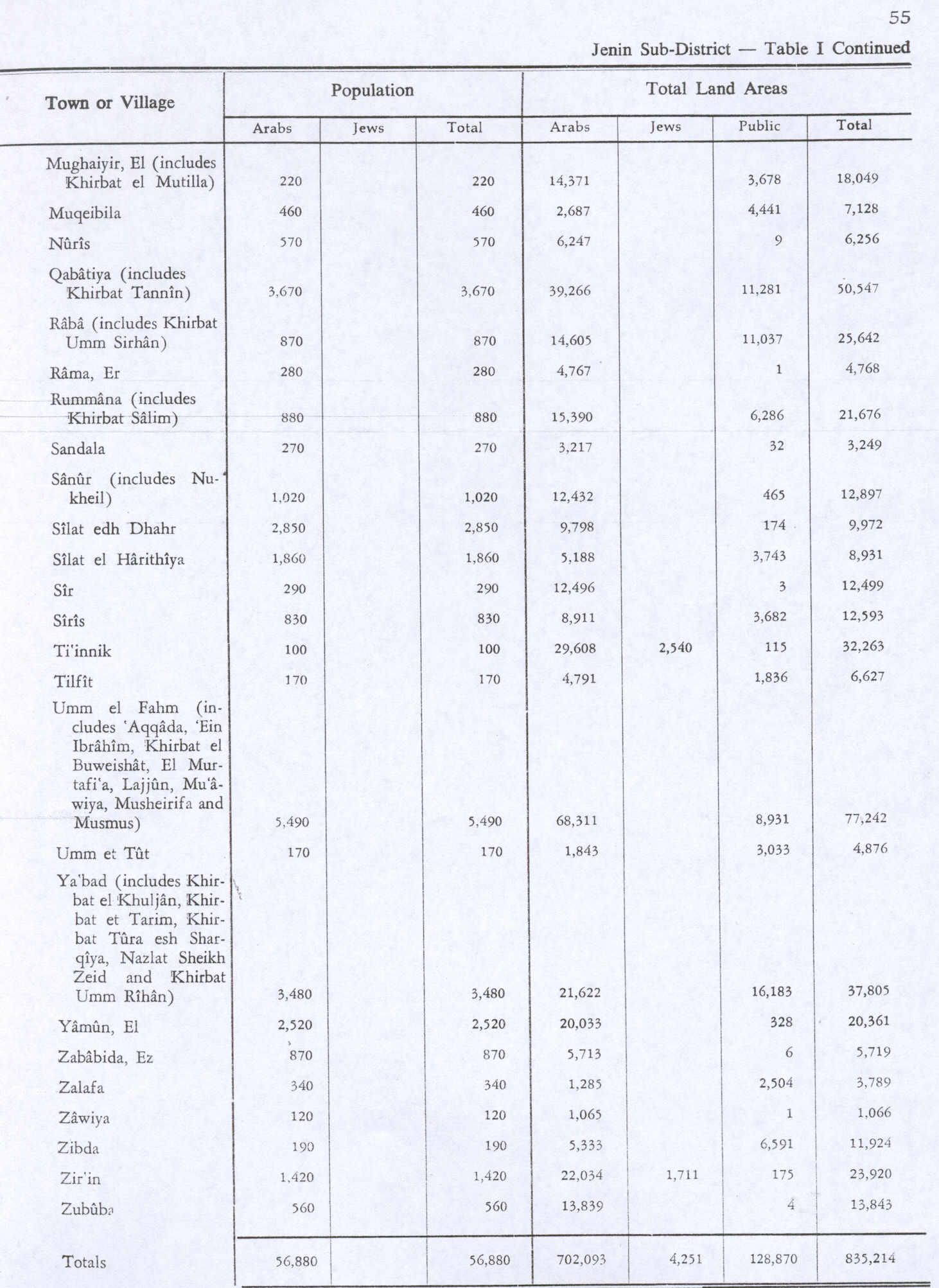
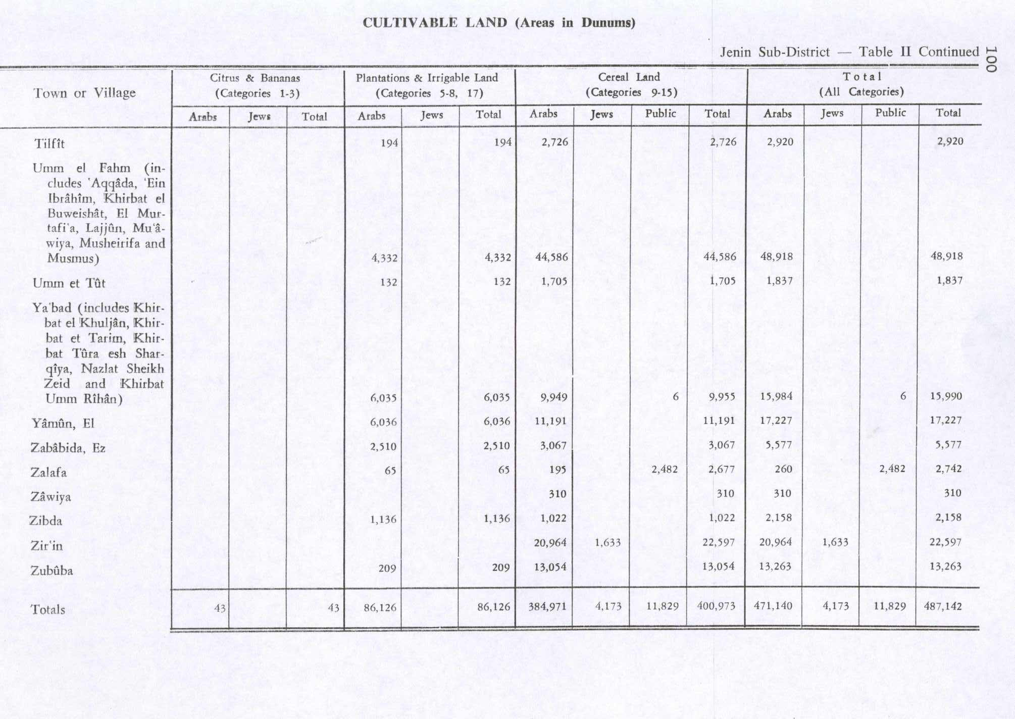
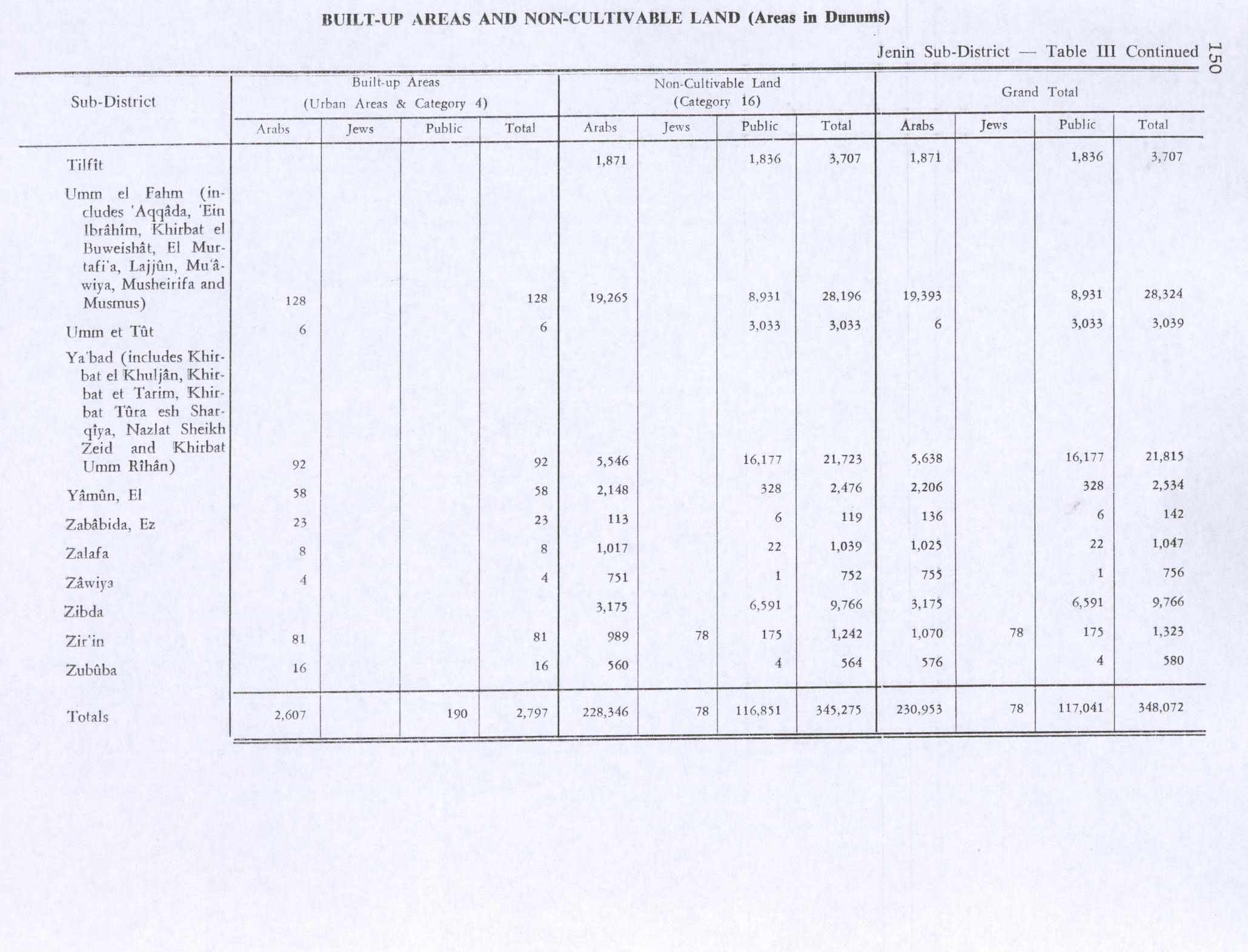
In the 1945 statistics, the population of Zibda was 190 Muslims,[14] with a total 11,924 dunams of land, according to an official land and population survey.[15] Of this, 1,136 dunams were used for plantations and irrigable land, 1,022 dunams were for cereals,[16] while a total of 6,591 dunams were classified as non-cultivable land.[17]
Jordanian era
[edit]Following the 1948 Arab–Israeli War, and the subsequent 1949 Armistice Agreements, Zibda came under Jordanian rule.
The Jordanian census of 1961 found 225 inhabitants.[18]
Israeli occupation
[edit]Since the 1967 Six-Day War, Zibda has been occupied by Israel.
The village has two tombs within it.[19]
Zibda was temporarily abandoned sometime after the 18th century due to war or blood feud between brothers, possibly during the Qays–Yaman war of 1840–1860.[8]
Demography
[edit]The village is dominated by the Amarnah family from Ya'bad.[8]
References
[edit]- ↑ Preliminary Results of the Population, Housing and Establishments Census, 2017 (PDF). Palestinian Central Bureau of Statistics (PCBS) (Report). State of Palestine. February 2018. pp. 64–82. Retrieved 2023-10-24.
- ↑ Palmer, 1881, p. 156
- 1 2 3 4 5 Zertal, 2016, pp. 288- 289
- ↑ Dauphin, 1998, p. 751
- ↑ al-Bakhīt, Muḥammad ʻAdnān; al-Ḥamūd, Nūfān Rajā (1989). "Daftar mufaṣṣal nāḥiyat Marj Banī ʻĀmir wa-tawābiʻihā wa-lawāḥiqihā allatī kānat fī taṣarruf al-Amīr Ṭarah Bāy sanat 945 ah". www.worldcat.org. Amman: Jordanian University. pp. 1–35. Retrieved 2023-05-15.
- ↑ Marom, Roy; Marom, Tepper; Adams, Matthew, J (2023). "Lajjun: Forgotten Provincial Capital in Ottoman Palestine". Levant. 55 (2): 218–241. doi:10.1080/00758914.2023.2202484. S2CID 258602184.
{{cite journal}}: CS1 maint: multiple names: authors list (link) - ↑ Hütteroth and Abdulfattah, 1977, p. 159
- 1 2 3 Grossman, D. (1986). "Oscillations in the Rural Settlement of Samaria and Judaea in the Ottoman Period". in Shomron studies. Dar, S., Safrai, S., (eds). Tel Aviv: Hakibbutz Hameuchad Publishing House. p. 345
- ↑ Robinson and Smith, 1841, vol 3, Appendix 2, p. 131
- ↑ Grossman, David (2004). Arab Demography and Early Jewish Settlement in Palestine. Jerusalem: Magnes Press. p. 257.
- ↑ Conder and Kitchener, 1882, SWP II, p. 72
- ↑ Barron, 1923, Table V, Sub-district of Jenin, p. 30
- ↑ Mills, 1932, p. 72
- ↑ Government of Palestine, Department of Statistics, 1945, p. 17
- ↑ Government of Palestine, Department of Statistics. Village Statistics, April, 1945. Quoted in Hadawi, 1970, p. 55
- ↑ Government of Palestine, Department of Statistics. Village Statistics, April, 1945. Quoted in Hadawi, 1970, p. 100
- ↑ Government of Palestine, Department of Statistics. Village Statistics, April, 1945. Quoted in Hadawi, 1970, p. 150
- ↑ Government of Jordan, Department of Statistics, 1964, p. 25
- ↑ Frantzman and Bar, 2013, p. 102
Bibliography
[edit]- Barron, J.B., ed. (1923). Palestine: Report and General Abstracts of the Census of 1922. Government of Palestine.
- Conder, C.R.; Kitchener, H.H. (1882). The Survey of Western Palestine: Memoirs of the Topography, Orography, Hydrography, and Archaeology. Vol. 2. London: Committee of the Palestine Exploration Fund.
- Dauphin, C. (1998). La Palestine byzantine, Peuplement et Populations. BAR International Series 726 (in French). Vol. III : Catalogue. Oxford: Archeopress. ISBN 0-860549-05-4.
- Frantzman, Seth J. and Doron Bar (2013). "Mapping Muslim Sacred Tombs in Palestine During the Mandate Period". Levant. 45 (1): 96–111. doi:10.1179/0075891412Z.00000000011. S2CID 162185684.
Zibda, Umm Safa and Sinjil in the northern central highlands had two [tombs] each.
- Government of Jordan, Department of Statistics (1964). First Census of Population and Housing. Volume I: Final Tables; General Characteristics of the Population (PDF).
- Government of Palestine, Department of Statistics (1945). Village Statistics, April, 1945.
- Hadawi, S. (1970). Village Statistics of 1945: A Classification of Land and Area ownership in Palestine. Palestine Liberation Organization Research Center.
- Hütteroth, W.-D.; Abdulfattah, K. (1977). Historical Geography of Palestine, Transjordan and Southern Syria in the Late 16th Century. Erlanger Geographische Arbeiten, Sonderband 5. Erlangen, Germany: Vorstand der Fränkischen Geographischen Gesellschaft. ISBN 3-920405-41-2.
- Mills, E., ed. (1932). Census of Palestine 1931. Population of Villages, Towns and Administrative Areas. Jerusalem: Government of Palestine.
- Palmer, E.H. (1881). The Survey of Western Palestine: Arabic and English Name Lists Collected During the Survey by Lieutenants Conder and Kitchener, R. E. Transliterated and Explained by E.H. Palmer. Committee of the Palestine Exploration Fund.
- Robinson, E.; Smith, E. (1841). Biblical Researches in Palestine, Mount Sinai and Arabia Petraea: A Journal of Travels in the year 1838. Vol. 3. Boston: Crocker & Brewster.
- Zertal, A. (2016). The Manasseh Hill Country Survey. Vol. 3. Boston: BRILL. ISBN 978-9004312302. (see also Tell esh-Sheikh Ṣabar, p. 285 ff and p. 78)
External links
[edit]- Welcome To Zibda
- Zibda, Welcome to Palestine
- Survey of Western Palestine, Map 8: IAA Archived 2014-10-15 at the Wayback Machine, Wikimedia commons
| Cities |  | |
|---|---|---|
| Municipalities |
| |
| Villages |
| |
| Refugee camps | ||
| Authority control databases: National |
|---|