


Wikipedia:Graphics Lab/Map workshop/Archive/Jun 2024
Latest comment: 2 years ago by LittleJerry in topic Lion range map
 | This is an archive of past discussions on Wikipedia:Graphics Lab, for the period 2024. Do not edit the contents of this page. If you wish to start a new discussion or revive an old one, please do so on the current main page. |
 | Archives of 2024: January, February, March, April, May, June, July, August, September, October, November, December |
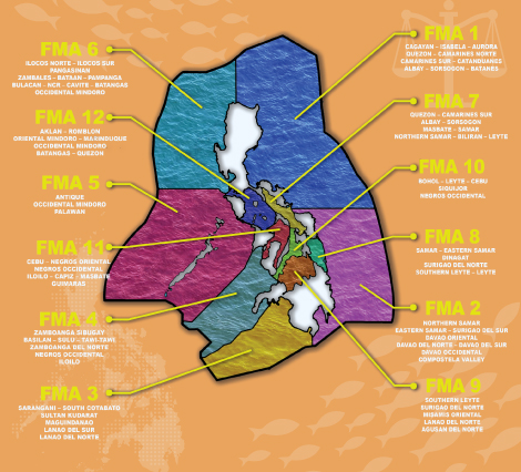
Philippine Fisheries Management Areas

 Png of EEZ, note the extension on the northeast which was made after the Fisheries Management Law not in the external links below.

- Article(s)
- Fisheries management
- Request
- In 2019 the Philippines divided its waters into 12 "Fisheries Management areas", covering both its territorial waters and its exclusive economic zone. There are some good maps of the original 12 out there eg. and eg., but not to my knowledge one on Wikipedia. I am not even sure we have an svg of the EEZ, the standard image we use is the png above. One interesting note on that png is it includes the Benham Rise, which was annexed after the creation of the FMAs. Supposedly this area got its own FMA, and while I can't find a map of that or the primary legislatoin it likely should be labelled separately, perhaps as "Philippine Rise". An svg would be best due to this, for easy modification of the label. As for the original 12, the legislation is Fisheries Administrative Order 263 which includes the precise borders of all 12 areas by latitude and longitude. CMD (talk) 09:16, 9 June 2024 (UTC)
- Discussion
- There seems to be KML data here but as the FoI portal is undergoing maintenance it is currently inaccessible. – Isochrone (talk) 16:37, 21 June 2024 (UTC)
Lion range map
 Current map


Article(s)
Request
- Requesting a new range map for the lion based on the 2023 IUCN Redlist map here