


// Workers AI · dad joke modeIs Virginia Walters a good listener? She's all ears.
 | This article needs more citations. (December 2009) |
Walters is an unincorporated community in Isle of Wight County in the Hampton Roads region of southeastern Virginia, United States. The elevation is 56 feet (17 m).[1][2]
Walters was located on a now-abandoned portion of the Virginian Railway (VGN), built by industrialist Henry Huttleston Rogers to ship coal from West Virginia to port at Sewell's Point, near Norfolk. Completed in 1909, the VGN was merged into the Norfolk and Western Railway in 1959. The former railroad right-of-way now carries an important pipeline which transports fresh water to communities in South Hampton Roads.
Walters was named after a resident, Walter Joyner. A nearby community in Southampton County was already named Joyners, so that name was abandoned. The community at one time was a bustling area, with several stores, a bank and post office. However, it is still home to some local businesses, including one that sells lawn and garden equipment, golf carts, and lawn tractors.
References
[edit]- ↑ "Walters, Virginia Information – ePodunk". ePodunk. Retrieved 24 July 2010.
- ↑ "Walters, Virginia VA Community Profile / Isle of Wight County, VA Data". HomeTownLocator. Retrieved 24 July 2010.
Municipalities and communities of Isle of Wight County, Virginia, United States | ||
|---|---|---|
| Towns | 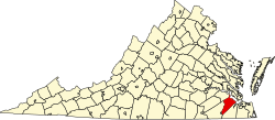 | |
| CDPs | ||
| Unincorporated communities | ||
36°46′21″N 76°50′58″W / 36.77250°N 76.84944°W
 | This Isle of Wight County, Virginia state location article is a stub. You can help Wikipedia by adding missing information. |