// Workers AI · dad joke modeWhat did Meiser say to his friend? "You miser my company
Meiser
| |
|---|---|
| Hebrew transcription(s) | |
| • Unofficial | Shaykh Maysar, Shaykh Maysir, Khirbat Maysar |
.jpg) | |
| Etymology: Sheikh Meisir, p.n.; meaning a certain gambling game with arrows.[1] | |
  Meiser Location within Haifa region of Israel  Meiser Location within Israel | |
| Coordinates: 32°26′41″N 35°2′31″E / 32.44472°N 35.04194°E | |
| Grid position | 203/705 ITM 154/205 PAL |
| Country |  Israel Israel |
| District | Haifa |
| Subdistrict | Hadera |
| Council | Menashe |
| Population (2024)[2] | 1,952 |
Meiser (Arabic: ميسر; Hebrew: מֵיסַר, also known as Shaykh Maysar or Khirbat Maysar) is an Arab village in northern Israel. Located half a kilometre west of the Green Line, north of the city of Baqa al-Gharbiyye in the triangle area of Wadi Ara, it is one of three Arab villages under the jurisdiction of Menashe Regional Council. In 2024 it had a population of 1,952.[2]
History
[edit]Roman Empire
[edit]Remains from the Early Roman era (end of the first century BCE–beginning of the first century CE) have been found here.[3][4][5] Three strata from the Roman-Byzantine periods was excavated in the centre of the village.[6] A bathhouse, dating from the same time, has also been found.[7]
Byzantine Empire
[edit]Ceramics and other remains from the Byzantine era have been found here.[4][8][9] An excavation revealed remains dating from the end of the Byzantine period (7th century CE), and above it were remains of a residential house from the Abbasid period (9th–10th centuries CE).[10]
Ottoman Empire
[edit]In 1882, the PEF's Survey of Western Palestine (SWP) found at Sheikh Meisir "foundations near a modern Mukam" (Muslim tomb).[11] In spite of this, Andrew Petersen, who inspected the Maqam in 1994, suggested "that the building may be considerably older than the nineteenth century."[12]
British Mandate
[edit]In the 1922 census of Palestine, conducted by the British Mandate authorities, Kherbet Maisir had a population of 49 Muslims.[13]
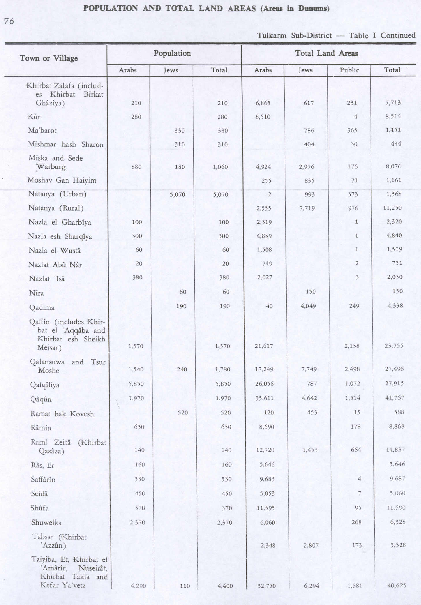
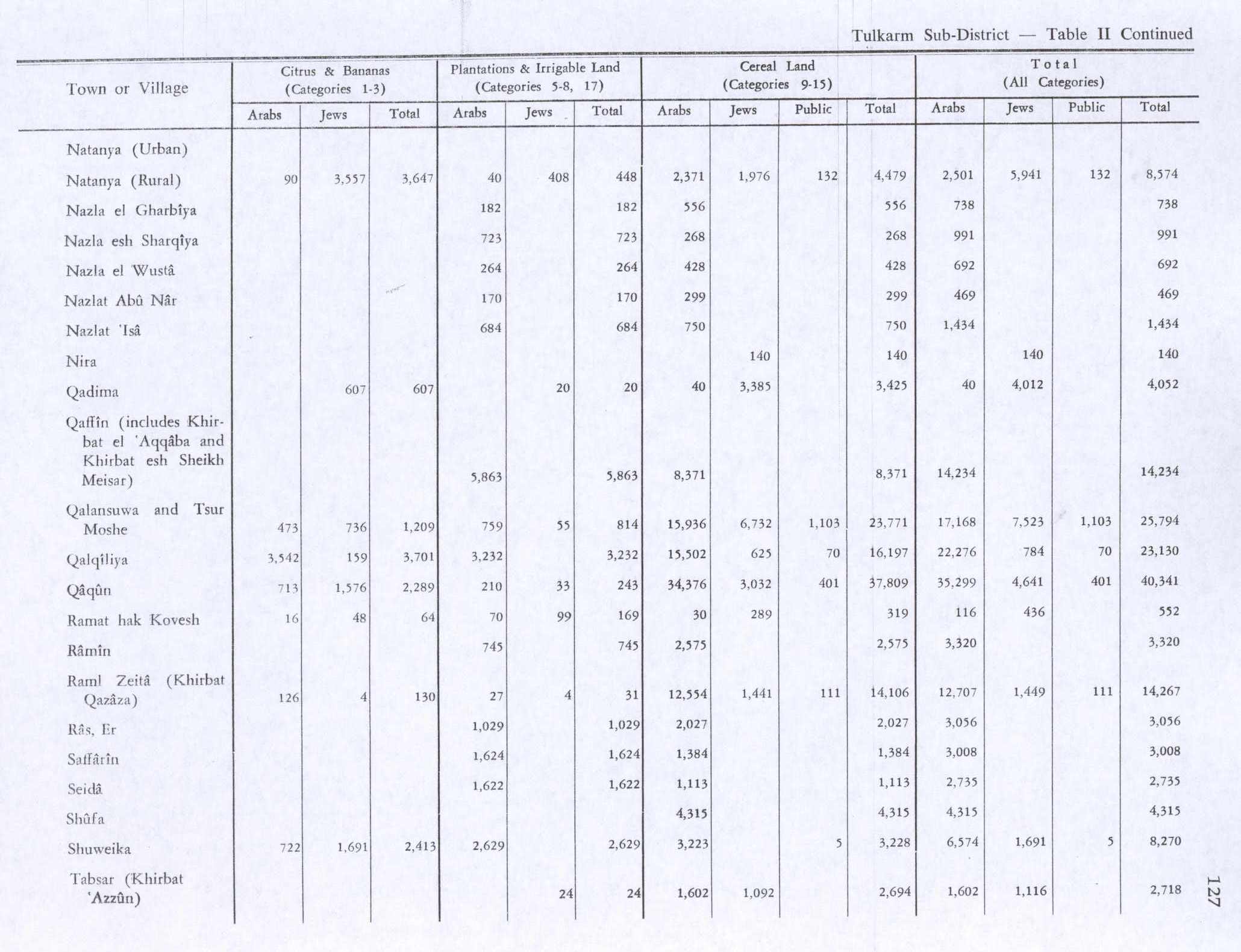
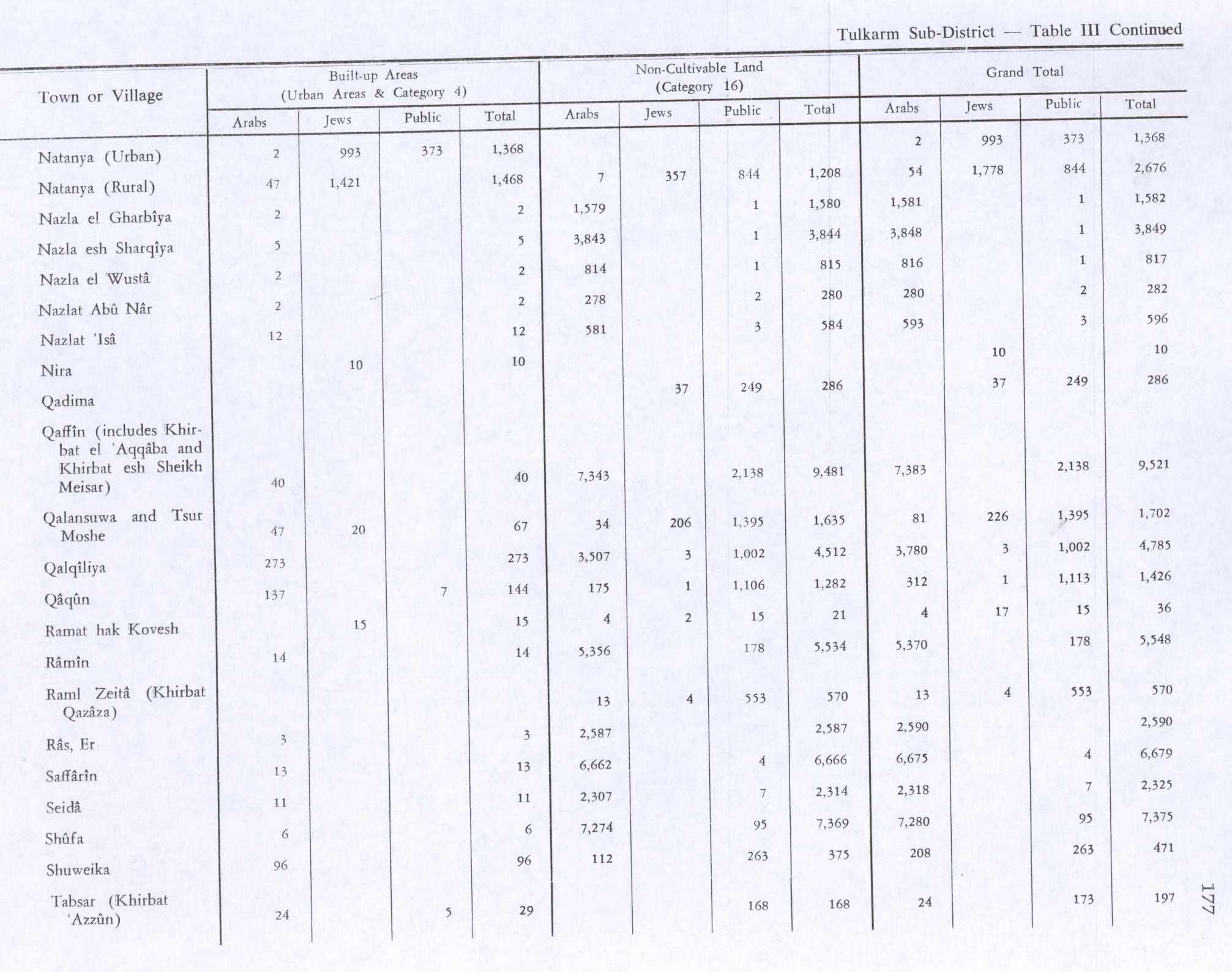
In the 1945 statistics Meiser was counted with Qaffin and Kh. el Aqaba, together they had a population of 1,570 Muslims,[14] with a land area of 23,755 dunams, according to an official land and population survey.[15] Of this, 5,863 dunams were plantations and irrigable land, 8,371 were used for cereals,[16] while 40 dunams were built-up (urban) land.[17]
 Meiser 1942 1:20,000
 Meiser 1945 1:250,000


See also
[edit]References
[edit]- ↑ Palmer, 1881, p. 152
- 1 2 "Regional Statistics". Israel Central Bureau of Statistics. Retrieved 21 March 2026.
- ↑ Dagot, 2007, Horbat Mesar
- 1 2 Zertal, 2016, pp. 292-294
- ↑ Massarwa, 2010, Horbat Mesar
- ↑ Sa‘id, 2009, Horbat Mesar
- ↑ Tabar and Gendelman, 2013, Horbat Mesar
- ↑ Dauphin, 1998, p. 752
- ↑ Massarwa, 2009, Horbat Mesar (North)
- ↑ Sa‘id, 2008, Horbat Mesar
- ↑ Conder and Kitchener, 1882, SWP II, p. 68
- ↑ Petersen, 2001, p. 283
- ↑ Barron, 1923, Table IX, Sub-district of Jenin, p. 30
- ↑ Department of Statistics, 1945, p. 21
- ↑ Government of Palestine, Department of Statistics. Village Statistics, April, 1945. Quoted in Hadawi, 1970, p. 76
- ↑ Government of Palestine, Department of Statistics. Village Statistics, April, 1945. Quoted in Hadawi, 1970, p. 127
- ↑ Government of Palestine, Department of Statistics. Village Statistics, April, 1945. Quoted in Hadawi, 1970, p. 177
Bibliography
[edit]- Barron, J.B., ed. (1923). Palestine: Report and General Abstracts of the Census of 1922. Government of Palestine.
- Conder, C.R.; Kitchener, H.H. (1882). The Survey of Western Palestine: Memoirs of the Topography, Orography, Hydrography, and Archaeology. Vol. 2. London: Committee of the Palestine Exploration Fund.
- Dagot, Angelina (2007-01-10). "Horbat Mesar". Hadashot Arkheologiyot – Excavations and Surveys in Israel (119).
- Dauphin, C. (1998). La Palestine byzantine, Peuplement et Populations. BAR International Series 726 (in French). Vol. III : Catalogue. Oxford: Archeopress. ISBN 0-860549-05-4.
- Department of Statistics (1945). Village Statistics, April, 1945. Government of Palestine.
- Hadawi, S. (1970). Village Statistics of 1945: A Classification of Land and Area ownership in Palestine. Palestine Liberation Organization Research Center.
- Massarwa, Abdallah (2009-06-23). "Horbat Mesar (North)". Hadashot Arkheologiyot – Excavations and Surveys in Israel (121).
- Massarwa, Abdallah (2010-03-30). "Horbat Mesar". Hadashot Arkheologiyot – Excavations and Surveys in Israel (122).
- Palmer, E.H. (1881). The Survey of Western Palestine: Arabic and English Name Lists Collected During the Survey by Lieutenants Conder and Kitchener, R. E. Transliterated and Explained by E.H. Palmer. Committee of the Palestine Exploration Fund.
- Petersen, Andrew (2001). A Gazetteer of Buildings in Muslim Palestine (British Academy Monographs in Archaeology). Vol. 1. Oxford University Press. ISBN 978-0-19-727011-0.
- Sa‘id, Kareem (2008-12-18). "Horbat Mesar". Hadashot Arkheologiyot – Excavations and Surveys in Israel (120).
- Sa‘id, Kareem (2009-12-07). "Horbat Mesar". Hadashot Arkheologiyot – Excavations and Surveys in Israel (121).
- Tabar, Murad Anton; Gendelman, Peter (2013-12-31). "Horbat Mesar". Hadashot Arkheologiyot – Excavations and Surveys in Israel (125).
- Zertal, A. (2016). The Manasseh Hill Country Survey. Vol. 3. Boston: BRILL. ISBN 978-9004312302.
External links
[edit]- Village website
- Welcome To Kh. al-Shaykh Meiser
- Survey of Western Palestine, Map 8: IAA, Wikimedia commons
Places adjacent to Meiser | |
|---|---|