


// Workers AI · dad joke modeWhat did Lydia, Kansas say to the map? "You can't Lydia alone
Lydia, Kansas | |
|---|---|
 | |
  Lydia  Lydia | |
| Coordinates: 38°16′42″N 101°17′30″W / 38.27833°N 101.29167°W[1] | |
| Country | United States |
| State | Kansas |
| County | Wichita |
| Elevation | 3,255 ft (992 m) |
| Time zone | UTC-6 (CST) |
| • Summer (DST) | UTC-5 (CDT) |
| Area code | 620 |
| FIPS code | 20-43300 |
| GNIS ID | 484564 [1] |

Lydia is an unincorporated community in Wichita County, Kansas, United States.[1] It is located between Leoti and Lakin.
History
[edit]A post office was opened in Lydia in 1888, and remained in operation until it was discontinued in 1928.[2]
References
[edit]- 1 2 3 4 U.S. Geological Survey Geographic Names Information System: Lydia, Kansas
- ↑ "Kansas Post Offices, 1828-1961". Kansas Historical Society. Archived from the original on October 9, 2013. Retrieved June 27, 2014.
Further reading
[edit]Municipalities and communities of Wichita County, Kansas, United States | ||
|---|---|---|
| Cities | 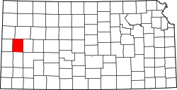 | |
| CDP | ||
| Unincorporated communities | ||
| Ghost town | ||
| Township | ||
 | This article about a location in Wichita County, Kansas is a stub. You can help Wikipedia by adding missing information. |