


// Workers AI · dad joke modeWhat did Kelly Butte say to its friend? "You're a rock.
| Kelly Butte | |
|---|---|
 Southeast aspect, summit to the right | |
| Highest point | |
| Elevation | 5,417 ft (1,651 m)[1] |
| Prominence | 1,280 ft (390 m)[2] |
| Isolation | 4.04 mi (6.50 km)[3] |
| Coordinates | 47°10′09″N 121°29′25″W / 47.1691552°N 121.4903139°W[1] |
| Geography | |
  Kelly Butte Location within Washington (state)  Kelly Butte Location within the United States | |
| Location | King County, Washington, U.S. |
| Parent range | Cascade Range |
| Topo map | USGS Lester |
| Geology | |
| Rock age | Miocene[4] |
| Volcanic plug[4] | |
| Rock type | Andesite[4] |
| Climbing | |
| Easiest route | hiking trail |
Kelly Butte is a 5,417-foot-elevation (1,651-meter) summit located in the southeast corner of King County in Washington state.[1] It is set on land managed by Mount Baker-Snoqualmie National Forest, and situated 3.1 mi (5.0 km) northwest of Colquhoun Peak and five miles west of the crest of the Cascade Range. Precipitation runoff from Kelly Butte drains into tributaries of the Green River. Topographic relief is significant as the west aspect rises 3,000 feet (910 meters) above Rock Creek in one mile. Access is via the 1.7-mile Kelly Butte Trail which leads to a restored, historical fire lookout tower originally constructed in 1926 and occupying the summit. Flora along the trail includes lilies, bear grass, Indian paintbrush, penstemon, arnica, columbine, lupine, phlox, and huckleberry. This geographical feature's name has been officially adopted by the U.S. Board on Geographic Names.[1]
Climate
[edit]Kelly Butte is located in the marine west coast climate zone of western North America.[5] Most weather fronts originate in the Pacific Ocean, and travel east toward the Cascade Mountains. As fronts approach, they are forced upward by the peaks of the Cascade Range (Orographic lift), causing them to drop their moisture in the form of rain or snowfall onto the Cascades. As a result, the west side of the Cascades experiences high precipitation, especially during the winter months in the form of snowfall. During winter months, weather is usually cloudy, but due to high pressure systems over the Pacific Ocean that intensify during summer months, there is often little or no cloud cover during the summer. The months July through October offer the most favorable weather for climbing this mountain.[6]
Gallery
[edit]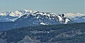 Southwest aspect of Kelly Butte seen from Sun Top
 South aspect of Kelly Butte (centered) as seen from Noble Knob,
with Colquhoun Peak to the right Kelly Butte Lookout
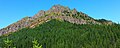 Southeast aspect
 Southeast aspect
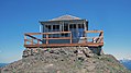 Kelly Butte lookout
 Mount Rainier seen from lookout
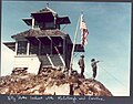 Kelly Butte lookout, original cupola cabin


_(22380841741).jpg)
See also
[edit]
References
[edit]- 1 2 3 4 "Kelly Butte". Geographic Names Information System. United States Geological Survey, United States Department of the Interior. Retrieved March 22, 2022.
- ↑ "Kelly Butte, Washington". Peakbagger.com.
- ↑ "Kelly Butte - 5,420' WA". listsofjohn.com. Retrieved March 22, 2022.
- 1 2 3 Beckey, Fred W. Cascade Alpine Guide: Columbia River to Stevens Pass. Seattle, WA: Mountaineers Books, 2000, page 81.
- ↑ Beckey, Fred W. Cascade Alpine Guide, Climbing and High Routes. Seattle, WA: Mountaineers Books, 2008.
- ↑ Michael Fagin, Skip Card (2003), Best Rain Shadow Hikes Western Washington, Mountaineers Books, ISBN 9780898868630, p. 149
External links
[edit]
- Weather forecast: Kelly Butte
- Kelly Butte Trail 1031: US Forest Service
- National Historic Lookout Register: Kelly Butte Lookout