Futiga, American Samoa
Futiga
Fūtiga | |
|---|---|
Village | |
  Futiga Location within American Samoa | |
| Coordinates: 14°21′12″S 170°45′15″W / 14.35333°S 170.75417°W | |
| Country |  United States United States |
| Territory |  American Samoa American Samoa |
| County | Tualatai |
| Area | |
• Total | 1.67 sq mi (4.33 km2) |
| Population (2020) | |
• Total | 682 |
| • Density | 408/sq mi (158/km2) |
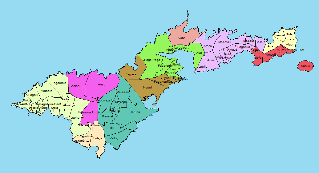
Futiga (Samoan: Fūtiga; Samoan pronunciation: [fuːtiŋa] ⓘ) is a village in the southwest of Tutuila Island, American Samoa. It is located inland, 7 miles (11 km) southwest of Pago Pago, between the villages of 'Ili'ili and Puapua. It is in Tualatai County.
Futiga is home of the Fagatele Bay Site, an archeological site which was added to the U.S. National Register of Historic Places in 1997.
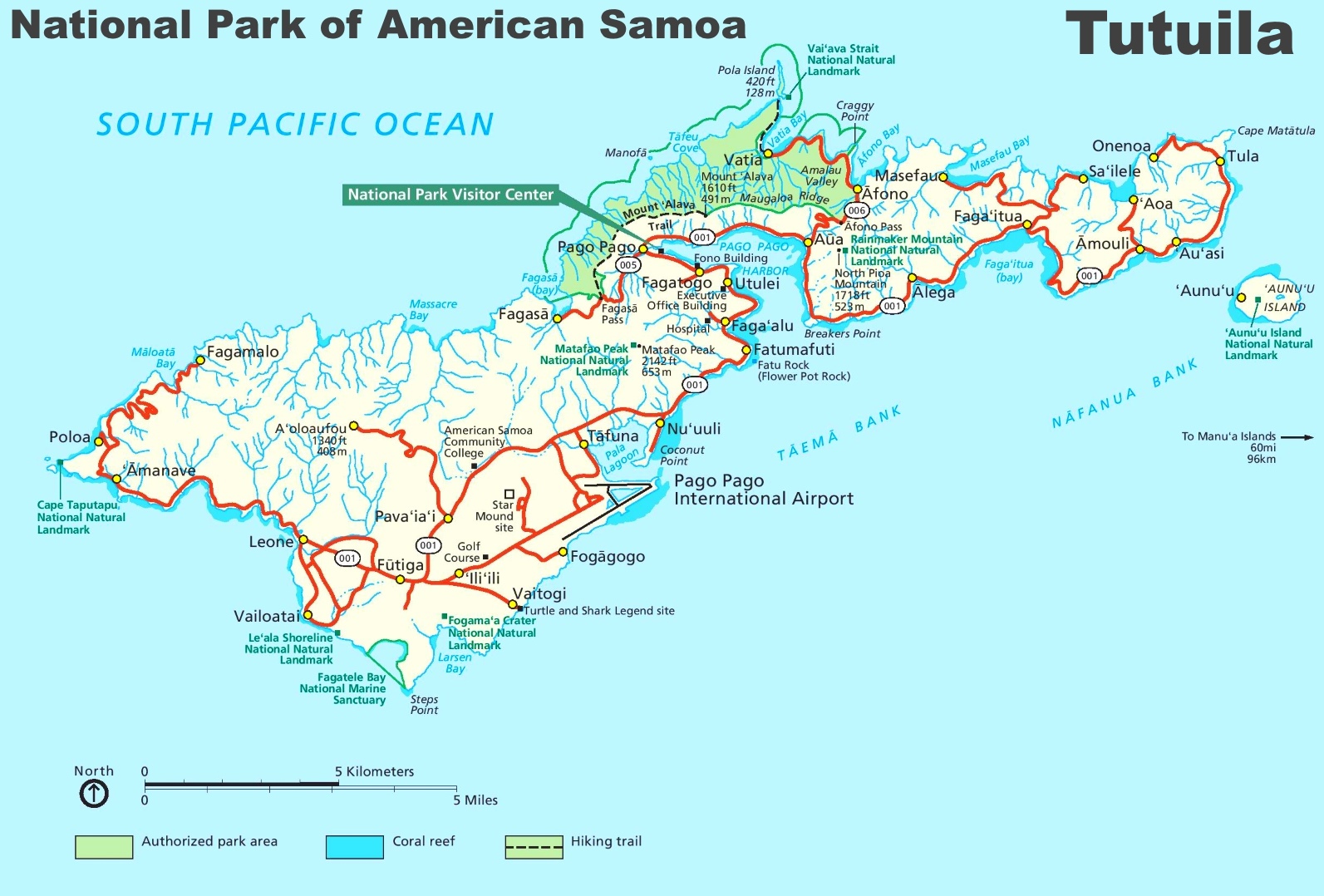
Futiga is the southernmost town in the United States (because it includes Steps Point).[1][2] (Rose Atoll is farther south, but is uninhabited.)[3]
Etymology
[edit]The name of the village, Futiga, is derived from the Samoan language and translates into English as “Plucking place".[4]
Geography
[edit]Fagatele Bay Trail is a 1-mile (1.6 km) roundtrip hiking trail to the Fagatele Bay National Marine Sanctuary from the village of Futiga. Fagatele Bay National Marine Sanctuary is a protected nature area home to animals such as turtles and sharks. When traveling west on Route 1 to Futiga, turn left just before US Mart. Follow the road past the landfill until you reach a locked gate. The trailhead is located here.[5]
Fogamaʻa Crater is a 485-acre (196 ha) site on the shoreline in the village of Futiga. The crater lies immediately inland from Larsen Bay, which makes up two smaller coves, Fogāma'a and Fagalua. The crater illustrates the most recent episode of volcanism in American Samoa.[6]
Futiga is home to the only landfill site in American Samoa. In 2018, it was reported that the landfill only had two years left before it reached its limit. American Samoa Power Authority was unable to find another site in the territory and instead began recompacting the site in Futiga. By digging up the landfill and recompacting it, the landfill may be usable for up to fifteen years longer.[7][8]
Fagatele Bay National Marine Sanctuary
[edit]

Access to Fagatele Bay National Marine Sanctuary is from the village of Futiga. Fagatele Bay is within National Marine Sanctuary of American Samoa and is one of two designated National Marine Sanctuaries in American Samoa. It is home to various species of animals, including hawksbill and green sea turtles. The nearest village is Taputimu, but the only access to the sanctuary is from Futiga.[9]
Fagatele Bay is a submerged volcanic crater surrounded by steep cliffs. It contains the last remaining stretch of coastal rainforest on Tutuila Island. A trail leads along Matautuloa Ridge to the lighthouse on the headland at Steps Point.[10]
Demographics
[edit]| Year | Population[11] |
|---|---|
| 2020 | 682 |
| 2010 | 723 |
| 2000 | 731 |
| 1990 | 720 |
| 1980 | 322 |
| 1970 | 288 |
| 1960 | 205 |
| 1950 | 166 |
| 1940 | 68 |
| 1930 | 36 |
Notable people
[edit]- A. U. Fuimaono, first Delegate-at-Large to the U.S. Congress from American Samoa. Also Director of Agriculture, Secretary of Samoan Affairs, and Senator.[12]
References
[edit]- ↑ http://ontheworldmap.com/usa/national-park/american-samoa/tutuila-tourist-map.jpg Ontheworldmap.com. Map of Tutuila (showing location of Steps Point). Retrieved July 4, 2020.
- ↑ https://www.oc.nps.edu/CMSP/AS/Tutuila_villages.png Oc.nps.edu. Tutuila villages map (showing location of Futiga). Retrieved July 4, 2020.
- ↑ Doug Mack. The Not-Quite States of America. page 91.
- ↑ Churchill, W. (1913). "Geographical Nomenclature of American Samoa". Bulletin of the American Geographical Society, 45(3), page 191. Retrieved on December 6, 2024, from https://doi.org/10.2307/199273.
- ↑ "Brochure" (PDF). www.nps.gov. Retrieved August 17, 2020.
- ↑ Goldin, Meryl Rose (2002). Field Guide to the Samoan Archipelago: Fish, Wildlife, and Protected Areas. Bess Press. Page 282. ISBN 9781573061117.
- ↑ "American Samoa gets 'prettier' landfill". February 7, 2018 – via www.bbc.com.
- ↑ "American Samoa landfill gets an extension". RNZ. February 6, 2018.
- ↑ World Conservation Monitoring Centre (1991). IUCN Directory of Protected Areas in Oceania. International Union for Conservation of Nature and Natural Resources. Pages 293-294. ISBN 9782831700694.
- ↑ Swaney, Deanna (1994). Samoa: Western & American Samoa: a Lonely Planet Travel Survival Kit. Lonely Planet Publications. Page 180. ISBN 9780864422255.
- ↑ "American Samoa Statistical Yearbook 2016" (PDF). American Samoa Department of Commerce. Archived from the original (PDF) on February 14, 2019. Retrieved July 25, 2019.
- ↑ Sunia, Fofō Iosefa Fiti (2001). Puputoa: Host of Heroes - A record of the history makers in the First Century of American Samoa, 1900-2000. Suva, Fiji: Oceania Printers. Page 39. ISBN 9829036022.