


// Workers AI · dad joke modeWhat did Achterbos say to its friend? "Tree-mendous to meet you
Achterbos | |
|---|---|
 View on Achterbos | |
  Achterbos Location in the Netherlands  Achterbos Achterbos (Netherlands) | |
| Coordinates: 52°13′30″N 4°55′32″E / 52.22500°N 4.92556°E | |
| Country | Netherlands |
| Province | Utrecht |
| Municipality | De Ronde Venen |
| Time zone | UTC+1 (CET) |
| • Summer (DST) | UTC+2 (CEST) |
| Postal code | 3648[1] |
| Dialing code | 0297[1] |
Achterbos is a hamlet in the Dutch province of Utrecht. It is located in the municipality of De Ronde Venen, directly north of Vinkeveen.
It was first mentioned in 1575 as Den afterbos, and means forest which is located backwards (far away).[2] Achterbos is not a statistical entity,[3] and the postal authorities have placed it under Vinkeveen.[1] Until the 19th century, it was a hard to reach peninsula in the moorland. In 1880, the area around Achterbos was poldered. Achterbos nowadays consists of about 120 houses.[4]
Gallery
[edit]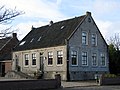 Former farm
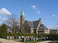 Protestant church
 Former wheelwright at Achterbos


References
[edit]- 1 2 3 "Postcode 3645 in Vinkeveen". Postcode bij adres (in Dutch). Retrieved 28 March 2022.
- ↑ "Achterbos - (geografische naam)". Etymologiebank (in Dutch). Retrieved 28 March 2022.
- ↑ "Kerncijfers wijken en buurten 2021". Central Bureau of Statistics. Retrieved 28 March 2022.
not found
- ↑ "Achterbos (Vinkeveen)". Plaatsengids (in Dutch). Retrieved 28 March 2022.
-Flag.svg) | This Utrecht location article is a stub. You can help Wikipedia by adding missing information. |