


State vector (navigation)
(Redirected from State vector (geographical))
 | This article needs more citations. (August 2026) |
In navigation, a state vector is a set of data describing exactly where an object is located in space, and how it is moving.[1][2][3]
Mathematical representation
[edit]A state vector typically will contain seven elements: three position coordinates, three velocity terms, and the time at which these values were valid.[citation needed] Mathematically, in order to describe positions in a N-dimensional space () then a state vector belongs to :


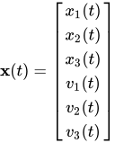
or simply
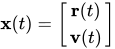
where is the position vector and is the velocity vector.


Since there is freedom to choose coordinate systems for position, a state vector may also be expressed in a variety of coordinate systems (e.g. the North east down coordinate system).
See also
[edit]References
[edit]- ↑ Michels, Walter C. (1956). The International dictionary of physics and electronics. Princeton, N.J.: Van Nostrand. p. 860.
- ↑ Diazdelcastillo, Alfonso; United States (1995). GOES & POLAR glossary. GOES and POLAR glossary. Washington, D.C.: U.S. Dept. of Commerce, National Oceanic and Atmospheric Administration, National Environmental Satellite Data Information Service, Office of Satellite Operations, Spacecraft Operations Control Center. p. 90.
- ↑ National Geodetic Survey (U.S.) (1986). Geodetic glossary. Rockville, MD: U.S. Dept. of Commerce, National Oceanic and Atmospheric Administration, National Ocean Service, Charting and Geodetic Services. p. 220.