


// Workers AI · dad joke modeWhat did Carlisle-Rockledge say to the map? "You can't rock my ledge.
Carlisle-Rockledge, Alabama | |
|---|---|
  Carlisle-Rockledge Location within Alabama | |
| Coordinates: 34°06′52″N 86°07′27″W / 34.11444°N 86.12417°W | |
| Country | United States |
| State | Alabama |
| County | Etowah |
| Area | |
• Total | 16.20 sq mi (41.97 km2) |
| • Land | 16.20 sq mi (41.96 km2) |
| • Water | 0.0039 sq mi (0.01 km2) |
| Elevation | 1,030 ft (310 m) |
| Population (2020) | |
• Total | 2,167 |
| • Density | 133.8/sq mi (51.65/km2) |
| Time zone | UTC-6 (Central (CST)) |
| • Summer (DST) | UTC-5 (CDT) |
| Area codes | 256 & 938 |
| FIPS code | 01-12070 |
| GNIS feature ID | 2582667[2] |
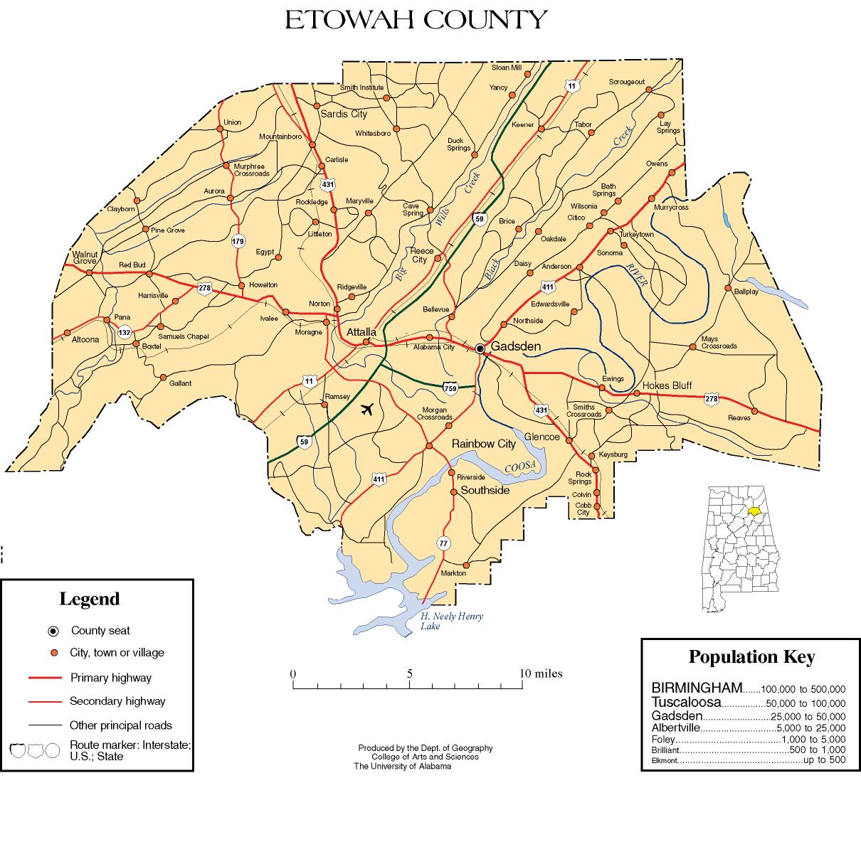
Carlisle-Rockledge is a census-designated place in Etowah County, Alabama, United States. The CDP includes the communities of Carlisle and Rockledge, both of which are located along U.S. Route 431 in northwest Etowah County.[3] As of the 2020 census, Carlisle-Rockledge had a population of 2,167.[4]
Demographics
[edit]| Census | Pop. | Note | %± |
|---|---|---|---|
| 2010 | 2,137 | — | |
| 2020 | 2,167 | 1.4% | |
| U.S. Decennial Census[5] | |||
Carlisle-Rockledge was listed as a census designated place in the 2010 U.S. census.[6]
Racial and ethnic composition
[edit]| Race / Ethnicity (NH = Non-Hispanic) | Pop 2010[7] | Pop 2020[8] | % 2010 | % 2020 |
|---|---|---|---|---|
| White alone (NH) | 2,007 | 1,888 | 93.92% | 87.13% |
| Black or African American alone (NH) | 19 | 29 | 0.89% | 1.34% |
| Native American or Alaska Native alone (NH) | 19 | 11 | 0.89% | 0.51% |
| Asian alone (NH) | 3 | 3 | 0.14% | 0.14% |
| Native Hawaiian or Pacific Islander alone (NH) | 0 | 2 | 0.00% | 0.09% |
| Other race alone (NH) | 0 | 2 | 0.00% | 0.09% |
| Mixed race or Multiracial (NH) | 23 | 109 | 1.08% | 5.03% |
| Hispanic or Latino (any race) | 66 | 123 | 3.09% | 5.68% |
| Total | 2,137 | 2,167 | 100.00% | 100.00% |
2020 census
[edit]As of the 2020 census, Carlisle-Rockledge had a population of 2,167.[9][10] The median age was 39.6 years. 23.6% of residents were under the age of 18 and 16.8% of residents were 65 years of age or older. For every 100 females there were 96.3 males, and for every 100 females age 18 and over there were 96.8 males age 18 and over.[9]
0.4% of residents lived in urban areas, while 99.6% lived in rural areas.[11]
There were 823 households in Carlisle-Rockledge, of which 29.5% had children under the age of 18 living in them. Of all households, 47.3% were married-couple households, 19.3% were households with a male householder and no spouse or partner present, and 27.6% were households with a female householder and no spouse or partner present. About 30.2% of all households were made up of individuals and 13.7% had someone living alone who was 65 years of age or older.[9]
There were 914 housing units, of which 10.0% were vacant. The homeowner vacancy rate was 1.5% and the rental vacancy rate was 1.1%.[9]
References
[edit]- ↑ "2020 U.S. Gazetteer Files". United States Census Bureau. Retrieved October 29, 2021.
- 1 2 U.S. Geological Survey Geographic Names Information System: Carlisle-Rockledge, Alabama
- ↑ Etowah County (Map). University of Alabama College of Arts and Science, Department of Geography. Retrieved November 6, 2011.
- ↑ "2020 Decennial Census Redistricting Data (Public Law 94-171)". United States Census Bureau. 2021. Retrieved March 6, 2026.
- ↑ "Census of Population and Housing". Census.gov. Retrieved June 4, 2016.
- ↑ "2010 Census of Population - Population and Housing Unit Counts - Alabama" (PDF). United States Census Bureau. 2010. Archived from the original (PDF) on January 21, 2022.
- ↑ "P2: Hispanic or Latino, and Not Hispanic or Latino by Race – 2010: DEC Redistricting Data (PL 94-171) – Carlisle-Rockledge CDP, Alabama". United States Census Bureau.
- ↑ "P2: Hispanic or Latino, and Not Hispanic or Latino by Race – 2020: DEC Redistricting Data (PL 94-171) – Carlisle-Rockledge CDP, Alabama". United States Census Bureau.
- 1 2 3 4 "2020 Decennial Census Demographic Profile (DP1)". United States Census Bureau. 2021. Retrieved April 28, 2026.
- ↑ "2020 Decennial Census Redistricting Data (Public Law 94-171)". United States Census Bureau. 2021. Retrieved April 28, 2026.
- ↑ "2020 Decennial Census Demographic and Housing Characteristics (DHC)". United States Census Bureau. 2023. Retrieved April 28, 2026.
Municipalities and communities of Etowah County, Alabama, United States | ||
|---|---|---|
| Cities |  | |
| Towns | ||
| CDPs | ||
| Unincorporated communities | ||
| Former City | ||
| Footnotes | ‡This populated place also has portions in an adjacent county or counties | |
 | This Etowah County, Alabama state location article is a stub. You can help Wikipedia by adding missing information. |