


Spree-Neiße
Spree-Neiße Wokrejs Sprjewja-Nysa | |
|---|---|
 Flag  Coat of arms | |
 | |
| Country | Germany |
| State | Brandenburg |
| Capital | Forst |
| Government | |
| • District admin. | Harald Altekrüger (CDU) |
| Area | |
• Total | 1,647.8 km2 (636.2 sq mi) |
| Population (31 December 2024)[1] | |
• Total | 109,635 |
| • Density | 66.534/km2 (172.32/sq mi) |
| Time zone | UTC+01:00 (CET) |
| • Summer (DST) | UTC+02:00 (CEST) |
| Vehicle registration | SPN, FOR, GUB, SPB |
| Website | www.landkreis-spree-neisse.de |
Spree-Neiße (Lower Sorbian: Wokrejs Sprjewja-Nysa [ˈwɔkrɛjs ˈsprʲɛwʲa ˈnɨsa]) is a Kreis (district) in the southern part of Brandenburg, Germany. Neighboring districts are (from the south clockwise) the districts Niederschlesischer Oberlausitzkreis and Kamenz in Saxony, the districts Oberspreewald-Lausitz, Dahme-Spreewald and Oder-Spree. The district-free city Cottbus is surrounded by the district. To the east is Poland.
Geography
[edit]The district is located in the region of Lusatia. The Spree river runs through the district, while the Lusatian Neisse river forms the eastern border, which is at the same time the border of Poland.
History
[edit]The district was created in 1993 by merging the previous districts Cottbus-Land, Forst, Guben and Spremberg.
Coat of arms
[edit]
The coat of arms shows four fields each representing one of the previous districts. The crayfish in the topleft symbolizes Cottbus-Land, and is also present in the coat of arms of the city of Cottbus. The lion in the topright is the symbol of the Kingdom of Bohemia, as Spremberg was owned by the Bohemian kings. The deer antler in the bottomright symbolizes Forst, and was taken from the coat of arms of the Lords of Biberstein. The crown in the bottomleft represents the kings of Bohemia again, but this time symbolizing Guben.
Towns and municipalities
[edit]
| Amt-free towns | Ämter | |
|---|---|---|
|
2. Döbern-Land |
3. Peitz
|
| 1seat of the Amt; 2town | ||
Demography
[edit]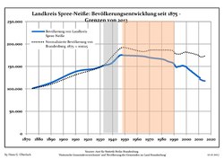 Development of Population since 1875 within the Current Boundaries (Blue Line: Population; Dotted Line: Comparison to Population Development of Brandenburg state)
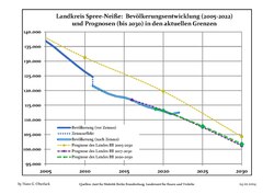 Recent Population Development and Projections (Population Development before Census 2011 (blue line); Recent Population Development according to the Census in Germany in 2011 (blue bordered line); Official projections for 2005-2030 (yellow line); for 2014-2030 (red line); for 2017-2030 (scarlet line)
Landkreis Spree-Neiße: Population development within the current boundaries (2017)[2] | ||||||||||||||||||||||||||||||||||||||||||||||||||||||||||||||||||||||||||||||||||||||||||||||||||||||||||||||||||||||||||||||||||||||||||||
|
|
| ||||||||||||||||||||||||||||||||||||||||||||||||||||||||||||||||||||||||||||||||||||||||||||||||||||||||||||||||||||||||||||||||||||||||||
References
[edit]- ↑ "Bevölkerungsstand im Land Brandenburg Dezember 2024 (Fortgeschriebene amtliche Einwohnerzahlen, basierend auf dem Zensus 2023)" (XLS). Amt für Statistik Berlin-Brandenburg (in German).
- ↑ Detailed data sources are to be found in the Wikimedia Commons.Population Projection Brandenburg at Wikimedia Commons
External links
[edit]
- Official website of the Landkreis Spree-Neiße (in German)
| Urban districts | |
|---|---|
| Rural districts | |


51°41′N 14°24′E / 51.683°N 14.400°E
| International | |
|---|---|
| National | |
| Other | |
