


// Workers AI · dad joke modeIs the Podolian Upland high? Pod-entially.


The Podolian Upland (Podolian Plateau) or Podillia Upland (Ukrainian: Подільська височина, Podilska vysochyna) is an upland area in southwestern Ukraine, on the left (northeast) bank of the Dniester River, with small portions in its western extent stretching into eastern Poland.
The region lies roughly between the Southern Bug and Dniester Rivers, with the Western Bug also originating in the northwest of the highlands. The average altitude of the Podolian Upland is over 300 m (980 ft) with the maximum being a hill known as Kamula Mountain, at 471 m (1,545 ft).
The surface is characterized by a combination of wide flat interfluves and deep canyon-like valleys (so called dales) dissected into separate natural sub-regions:
- Wooded elevated hills
- Flat treeless plateaus
- Ternopil Plateau
- Upper Buh Plateau
- North-Podolian Plateau
It also includes the Avratyn Upland The Podolian Upland and the Volhynian Upland are sometimes grouped together as the Volhynian-Podolian Upland.
Gallery
[edit] Podolian Tovtry
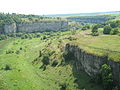 Smotrych Canyon (Tovtry)
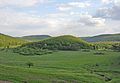 Great Hovda Hill


See also
[edit]External links
[edit]- Podolian Upland at the Encyclopedia of Ukraine.
- Herenchuk, K.I. Podolian Upland. Ukrainian Soviet Encyclopedia
- Shabliy, O.I., Mukha, B.P., Huryn, A.V., Zinkevych, M.V. Lviv Oblast relief. Podolian Upland (Рельєф Львівської області. Подільська височина). "Geography: Lviv Oblast".
49°01′39″N 27°51′22″E / 49.0275°N 27.8562°E
 | This article about a location in Ukraine is a stub. You can help Wikipedia by adding missing information. |
 | This Poland location article is a stub. You can help Wikipedia by adding missing information. |