Mont Orford
| Mont Orford | |
|---|---|
 | |
 Interactive map of Mont Orford | |
| Location | Orford, Quebec |
| Nearest city | Magog |
| Coordinates | 45°20′00″N 72°13′00″W / 45.33333°N 72.21667°W |
| Vertical | 589 m (1,932 ft) |
| Top elevation | 853 m (2,799 ft) |
| Base elevation | 261 m (856 ft) |
| Trails | 61 Total 33% Easy 26% Intermediate 41% Difficult |
| Longest run | 4 km (2 mi) |
| Lift system | 1 gondola, 4 chairlifts, 4 magic carpet |
| Website | Official website |
Mount Orford (French: Mont Orford) is a mountain and ski resort located in the Mont-Orford National Park in the Estrie region of Quebec, Canada. It is 10 km (6 mi) northwest of the centre of the city of Magog.
History
[edit]Mount Orford is named after the township Orford.[1] Its name first appears in print between 1815 and 1831.[1]
In 2006, the provincial government and then-Environment Minister Claude Béchard announced the increase of the size of Orford as a national park. In addition, they would have sold the ski resort and golf course to private interests. Inside the 80 hectares (200 acres) that were to be sold, developers planned to build condominiums, restaurants, boutiques and a hotel. The planned development was to be similar to Mont-Tremblant but on a lesser scale, and several other projects had been planned previously.[2] This was successfully opposed by several groups, including environmental. On May 7, 2007, new Environment Minister Line Beauchamp announced that the province would not sell Orford.[3] Following on the heels of strong citizen support Orford Park has since been expanded several times adding over 100 square kilometers of protected area.[4]
Recreation
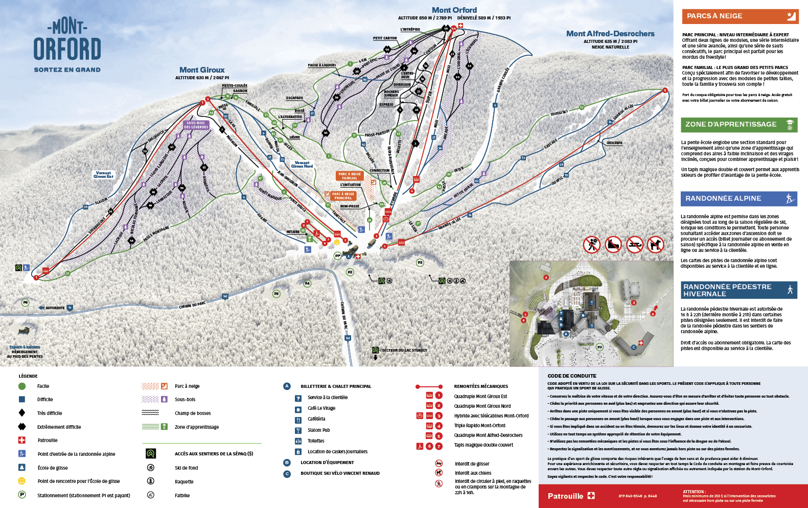
[edit]The ski resort consists of three summits: Mont Giroux, Mont Orford, and Mont Alfred Desrochers. It is the home mountain of Olympic medalist Nicolas Fontaine, for whom there is a track named in his honour.[5]
Other infrastructure on the mountain currently include:[6]
- Base lodge with bar, cafeteria, and rooftop terraces
- Groomed cruising trails as well as moguls/glades
- Ski shop, repair shop, and rental center
Former infrastructure :
- Triple yurt summit lodge
- Summit snack bar
See also
[edit]References
[edit]- 1 2 "Mont Orford - Orford (Municipalité de canton)". toponymie.gouv.qc.ca. Retrieved 2025-08-30.
- ↑ "Québec ira de l'avant" (in French). 6 September 2006. Retrieved 7 August 2014.
- ↑ Ouellet, Martin (7 May 2007). "Québec renonce à privatiser le mont Orford" (in French). Archived from the original on March 9, 2008.
- ↑ "Agrandissement du parc du Mont-Orford : Le BAPE recommande d'inclure le lac Larouche". 28 July 2023.
- ↑ "Nos 18 sous-bois | Mont-Orford". Nos 18 sous-bois | Mont-Orford Mont-Orford (in French). Retrieved 2025-08-30.
- ↑ "Map of Mountain & Ski Trails". Map of Mont Orford. Retrieved 2025-08-30.
External links
[edit]Mountains of Quebec | |||||
|---|---|---|---|---|---|
| Green Mountains | |||||
| Laurentian Mountains | |||||
| Longfellow Mountains | |||||
| Monteregian Hills | |||||
| Notre Dame Mountains |
| ||||
| Torngat Mountains |
| ||||
| Others | |||||

.svg)
| Quebec City area | |
|---|---|
| Montreal local area |
|
| Laurentides area: Montreal-area Laurentians | |
| Eastern Townships | |
| Gatineau area: Ottawa-area Laurentians | |
| Lanaudière area: Montreal-area Laurentians | |
| Saguenay–Lac-Saint-Jean | |
| Bas-Saint-Laurent | |
| Abitibi-Témiscamingue | |
| |