


// Workers AI · dad joke modeWhat did the 2025-26 cyclone say? It's a "twisting" tale.

| 2025–26 South-West Indian Ocean cyclone season | |
|---|---|
 Season summary map | |
| Seasonal boundaries | |
| First system formed | 16 July 2025 |
| Last system dissipated | 27 April 2026 |
| Strongest storm | |
| By maximum sustained winds | Horacio |
| • Maximum winds | 215 km/h (130 mph) (10-minute sustained) |
| • Lowest pressure | 947 hPa (mbar) |
| By central pressure | Dudzai |
| • Maximum winds | 205 km/h (125 mph) (10-minute sustained) |
| • Lowest pressure | 937 hPa (mbar) |
| Seasonal statistics | |
| Total disturbances | 14, 1 unofficial |
| Total depressions | 13, 1 unofficial |
| Total storms | 11, 1 unofficial |
| Tropical cyclones | 6 |
| Intense tropical cyclones | 4 |
| Very intense tropical cyclones | 0 |
| Total fatalities | 75+ |
| Total damage | > $2.48 billion (2026 USD) (Third-costliest South-West Indian Ocean cyclone season on record) |
| Related articles | |
The 2025–26 South-West Indian Ocean cyclone season was an active and very destructive South-West Indian Ocean cyclone season. Although only 2 storms did measurable damage, it was the third costliest on record, mainly due to Cyclone Gezani, which itself became the costliest cyclone in Madagascar’s history. It officially began on 15 November 2025, and ended on 30 April 2026, with the exception for Mauritius and the Seychelles, for which it ended on 15 May 2026. These dates conventionally delimit the period of each year when most tropical and subtropical cyclones form in the basin, which is west of 90°E and south of the Equator. However, tropical cyclones can form year-round with any cyclone forming between 1 July 2025 and 30 June 2026, such as 01, Awo, Blossom and Chenge, also part of the season. Tropical and subtropical cyclones in this basin are monitored by the Regional Specialised Meteorological Centre in Réunion and unofficially by the Joint Typhoon Warning Center.
Seasonal forecasts
| Record | Moderate Tropical Storm |
Tropical Cyclone | ||||
|---|---|---|---|---|---|---|
| Average | 10 | 5 | ||||
| Record high | 15 (2018–19) | 11 (2018–19) | ||||
| Record low | 3 (1982–83) | 0 (1982–83) | ||||
| Forecast center |
Systems | |||||
| Météo-France | 10–14 | 5–8 | ||||
| Mauritius Meteorological Services | 11–13 | N/a | ||||
| Forecast center |
Chance of below/near/above average | |||||
| Météo-France | 10% | 40% | 50% | |||
| Sources:[1][2] | ||||||
Seasonal summary

Pre-season/early season activity
 | This section has multiple issues. Please help improve it or discuss these issues on the talk page. (Learn how and when to remove these messages)
|


The season began with the crossover of a tropical low from the Australian basin on 16 July. The low was designated Tropical Depression 01 by Météo-France, while the JTWC designated the depression as Tropical Storm 01S a little later.[citation needed] The system did not strengthen and dissipated 2 days later without affecting land. On 7 August, a tropical disturbance formed well north of the Mascarenes, later that day it was upgraded to a tropical depression then subsequently named Awo that evening as it strengthened into a Moderate Tropical Storm. Awo was the first named storm to form in August within the South-West Indian Ocean basin since Severe Tropical Storm Aline in 1969, though Severe Tropical Storm Tony did enter the basin during August in 1979. Awo only briefly survived, encountering high shear and dissipating the next day. On 7 September, Météo–France started monitoring a disturbance south of Diego Garcia. Briefly on 9 September, it intensified into a tropical depression. The system was then classified as a Moderate Tropical Storm and named Blossom, becoming the second named storm of the season. Blossom maintained its intensity in a marginal environment, before degenerating into a remnant low–pressure area on 11 September. On 17 October, a low–pressure area formed near Diego Garcia and was marked by Météo-France as the fourth Zone of Disturbed Weather of the season, the fourth off-season system of the season. After strengthening into a Moderate Tropical Storm, it was named Chenge. Heading westward, the cyclone further strengthened into a Severe Tropical Storm on 22 October before weakening. On 25 October, Chenge degenerated into a remnant low off the coast of Tanzania. Following these early and off-season systems, the basin experienced a prolonged period of inactivity leading into the official start of the season. Activity resumed on 27 December when Tropical Cyclone Grant entered the South-West Indian Ocean from the Australian region, retaining its name as it crossed basin boundaries. Grant dissipated in early January after rapidly intensifying into an Intense Tropical Cyclone in the central part of the basin, far from land.
Peak season activity
On 8 January, Cyclone Jenna crossed the 90th meridian east from the Australian region into the South-West Indian Ocean basin. Météo-France did not monitor the system, labeling it as a "residual depression". The Joint Typhoon Warning Center continued to monitor the system as a tropical storm for a short time before its degeneration into a remnant low on 9 January.[citation needed] On 10 January, Cyclone Dudzai developed in the central part of the basin, becoming the second intense tropical cyclone of the season. Dudzai’s formation marked a transition to more typical mid-season conditions, characterized by warmer sea-surface temperatures and reduced wind shear, which supported stronger and more sustained cyclonic development within the basin.[3] Dudzai then weakened quickly immediately after intensifying, before accelerating westward and quickly intensified once again, before becoming extratropical as it recurved away from land. While it was dissipating, on 20 January, Ewetse formed and quickly made landfall in southwestern Madagascar as a Moderate Tropical Storm the next day. Six days later, Zone of Disturbed Weather 08 formed but quickly dissipated the following day as it merged into a monsoon trough. Fytia formed the following day and rapidly intensified before making landfall in northwestern Madagascar as a high–end Tropical Cyclone on 31 January. After crossing Madagascar, it dissipated south of Réunion. twelve were killed in Madagascar from the storm. On 8 February, Gezani formed. It slowly strengthened and made landfall in Madagascar as an Intense Tropical Cyclone, causing over 63 casualties. Then it later impacted Mozambique as a Tropical Cyclone. On February 24, Cyclone Horacio formed and became a Category 5 tropical cyclone on the SSHWS scale, the first to do so in the southern hemisphere since Errol in April 2025, and the first globally of 2026.
Late season activity
Tropical Depression 12 formed on March 12 but it quickly weakened and dissipated the following day. Cyclone Indusa formed on April 1 and it rapidly intensified into a tropical cyclone on April 4. An extratropical cyclone formed on April 26, it later developed subtropical characteristics, and was named Juluka the following day.
Systems
Tropical Depression 01
| Tropical depression (MFR) | |
| Tropical storm (SSHWS) | |
  | |
| Duration | 16 July (Entered basin) – 18 July |
|---|---|
| Peak intensity | 55 km/h (35 mph) (10-min); 1000 hPa (mbar) |
On 16 July, a tropical low moved from the Australian Region into the South-West Indian Ocean, where it was classified as Zone of Disturbed Weather 01 by Météo-France. On the same day, the JTWC upgraded the system to a tropical storm, assigning it the designation 01S.[4][5] The system moved west-southwestwards into an increasingly unfavourable environment, dissipating on 18 July.[6]
Moderate Tropical Storm Awo
| Moderate tropical storm (MFR) | |
| Tropical storm (SSHWS) | |
  | |
| Duration | 6 August – 8 August |
|---|---|
| Peak intensity | 75 km/h (45 mph) (10-min); 1000 hPa (mbar) |
On 6 August, a tropical disturbance formed in the central Indian Ocean and on the northeast of Madagascar. A day later, the JTWC designated the system as Tropical Storm 02S, while MFR designated the system as Tropical Depression 02.[7] Six hours later, Mauritius Meteorological Services upgraded it to moderate tropical storm status and named it Awo.[8] Awo is the first named storm to form in August within the South-West Indian Ocean basin since Severe Tropical Storm Aline in 1969, though Severe Tropical Storm Tony did enter the basin during August in 1979.[citation needed] Awo struggled to intensify due to persistent easterly wind shear and limited upper‑level outflow, which prevented further organization. Throughout its lifespan, the system remained poorly structured, with most convection displaced away from the low‑level center. Increasing shear and dry air intrusion caused Awo to weaken steadily before dissipating.[9][10][11]
Moderate Tropical Storm Blossom
| Moderate tropical storm (MFR) | |
| Tropical storm (SSHWS) | |
  | |
| Duration | 9 September – 12 September |
|---|---|
| Peak intensity | 65 km/h (40 mph) (10-min); 1003 hPa (mbar) |
![[icon]](/everything/wiki/File:Wiki_letter_w_cropped.svg) | This section needs expansion. You can help by making an edit requestadding missing information. (February 2026) |
Meteo-France Réunion began monitoring a disturbance on 7 September. At 10:00 a.m. (0600Z) on 9 September, MFR upgraded it to Tropical Depression status, marking it as Tropical Depression 03.[12] By the next advisory it weakened back to a Tropical Disturbance. On 10 September it once again intensified into a Tropical Depression. On 11 September, it strengthened once again, this time strengthening into a Moderate Tropical Storm, thus receiving the name Blossom. It weakened shortly after and dissipated the next day.[13]
Severe Tropical Storm Chenge
| This section needs expansion. You can help by making an edit requestadding missing information. (November 2025) |
| Severe tropical storm (MFR) | |
| Tropical storm (SSHWS) | |
  | |
| Duration | 17 October – 25 October |
|---|---|
| Peak intensity | 95 km/h (60 mph) (10-min); 985 hPa (mbar) |
On 17 October, a low–pressure area formed near Diego Garcia and was marked by Météo-France as the fourth Zone of Disturbed Weather of the season. It was then classified as Moderate Tropical Storm Chenge. Early on 22 October, Chenge intensified into a Severe Tropical Storm. Chenge then went on to move in a mostly western trajectory, passing north of Madagascar before entering increasingly unfavorable conditions and weakening into a tropical depression. Chenge dissipated on 25 October. After dissipation, the remnants of Chenge were absorbed into a broader monsoonal flow over East Africa.
As the storm passed north of Madagascar, only minor effects such as increased swells and occasional rainbands were observed over nearby islands, including the Glorioso Islands and Juan de Nova. No significant damage was reported and producing scattered rainfall over parts of Kenya and Tanzania without causing notable impacts.[14]
Intense Tropical Cyclone Grant
| Intense tropical cyclone (MFR) | |
| Category 4 tropical cyclone (SSHWS) | |
  | |
| Duration | 27 December (Entered basin) – 6 January |
|---|---|
| Peak intensity | 205 km/h (125 mph) (10-min); 940 hPa (mbar) |
On 27 December, Grant entered the basin from the Australian Region at 10:00 RET (06:00 UTC) as a severe tropical storm.[15] Twenty-four hours later, the system became a tropical cyclone.[16] After rapid intensification, Grant was upgraded to an intense tropical cyclone at 0:00 UTC on December 29, equivalent to a Category 3 hurricane on the Saffir-Simpson scale, about 1300 km southeast of Diego Garcia, the first major cyclone of the season in the South-West Indian Ocean Basin.[17][18] At 15:00 UTC, the Joint Typhoon Warning Center (JTWC) upgraded it to category 4.[19] Grant remained at slightly below its peak intensity for more than 42 hours before weakening back to a tropical cyclone, according to RSMC La Réunion, on December 31 at 12:00 UTC, as it entered an area of dry air and upper-level wind shear. It was then 900 km east-northeast of Rodrigues.[20] On January 1, 2026, at 6:00 UTC, Grant was downgraded to a severe tropical storm and then to a moderate tropical storm 6 hours later, more than 600 km northeast of Rodrigues.[21] The next day at 12:00 UTC, the system was downgraded again, this time to a tropical depression.[22] On Sunday, January 4th, the center of the system passed about 85 kilometres (53 mi) North of St. Brandon, bringing bands of heavy showers and thunderstorms with swells of 3 to 4 meters.[23] On January 5, the Regional Specialized Meteorological Centre (RSMC) La Réunion issued its final bulletin for Grant, which had weakened into a tropical disturbance passing between 50 and 100 km southeast of Tromelin Island. The remnants of the system were heading towards the southern coast of the Toamasina Province in Madagascar, which it was expected to reach within two days.[24]
Intense Tropical Cyclone Dudzai
| Intense tropical cyclone (MFR) | |
| Category 4 tropical cyclone (SSHWS) | |
  | |
| Duration | 10 January – 21 January |
|---|---|
| Peak intensity | 205 km/h (125 mph) (10-min); 937 hPa (mbar) |
At 12:00 UTC on 10 January, the RSMC La Réunion estimated that a tropical disturbance it had been monitoring for a few days was sufficiently organized to be declared a tropical depression at 800 km southeast of the Chagos Archipelago.[25] Later that day, it was given the name Dudzai as it intensified into a moderate tropical storm. Dudzai would then strengthen into a severe tropical storm the following day. By 12 January, it had rapidly intensified into an intense tropical cyclone.[26] Dudzai then encountered less favorable conditions and its very slow movement produced an upwelling of cooler water from the depths, all leading to a gradual weakening. On 13 January, its trajectory also turned westward.[27] On 14 January, the system temporarily weakened back to a strong tropical storm, while accelerating towards the Mascarene Islands, before returning to a tropical cyclone with an improvement in environmental conditions.[28] On 15 January, Dudzai restrengthened into an intense tropical cyclone and increased its gale-force wind radius. On 16 January, Dudzai reached its second peak intensity with maximum sustained winds of 195 km/h and a minimum central pressure of 945 millibars. Soon after reaching its peak intensity the cyclone began to weaken due to an eyewall replacement cycle. On 17 January, Dudzai weakened back into a severe tropical storm and a cyclone warning was issued for Rodrigues island by the Mauritius Meteorological Services.[29] On 18 January, the center of the system moved approximately 180 km southeast of the island where Air Mauritius had cancelled all flights to and from Rodrigues.[30][31] The storm then passed approximately 300 km southeast of Réunion and Mauritius, both of which were placed on weather warning due to the effects of the cyclonic swell on sea conditions and potential of coastal flooding.[32] Subsequently, Dudzai's track curved southward and then southeastward, and on 21 January, it passed south of the 30th parallel south, reaching colder waters and becoming extratropical, eventually merging with a frontal boundary.
Severe Tropical Storm Ewetse
| Severe tropical storm (MFR) | |
| Tropical storm (SSHWS) | |
  | |
| Duration | 19 January – 21 January |
|---|---|
| Peak intensity | 95 km/h (60 mph) (10-min); 992 hPa (mbar) |
On 20 January, MFR started monitoring a non-tropical low pressure area along a frontal boundary in the southern Mozambique Channel for possible development. Later that day it was upgraded into a tropical depression. A few hours after that, it was upgraded to Moderate tropical storm, thus receiving the name Ewetse. The storm made landfall near Itampolo shortly after 6:00 UTC on the 21st and weakened rapidly over the mountainous terrain as it moved north. The RSMC La Réunion issued its final bulletin at 12:00 UTC.[33]
In Mozambique, although the storm’s centre remained offshore, Ewetse’s outer bands exacerbated a severe humanitarian crisis. The country was already under a national red alert due to weeks of torrential rain that had flooded the Limpopo and Incomati river basins. The storm generated a storm surge of 0.7 m (2.3 ft) near Ambanhe and brought additional heavy rainfall to the Gaza and Inhambane provinces, where over 600,000 people had already been affected by flooding.[34]
In Madagascar, Ewetse primarily impacted the Toliara Province. While wind damage was limited, the system delivered significant rainfall, with totals exceeding 150 mm (5.9 inches) in local areas. These rains triggered flash flooding in the southern districts, though they were also noted for providing some relief to regions that had been suffering from prolonged drought. No fatalities were directly attributed to the storm's landfall, but local authorities remained on high alert as the system moved through areas with high vulnerability and poor drainage infrastructure.[35][36][37]
Tropical Cyclone Fytia
| Tropical cyclone (MFR) | |
| Category 3 tropical cyclone (SSHWS) | |
.jpg)  | |
| Duration | 29 January – 4 February |
|---|---|
| Peak intensity | 155 km/h (100 mph) (10-min); 960 hPa (mbar) |
On 28 January, Météo-France (MFR) began tracking an area of low pressure, designated as Zone of Disturbed Weather 09, located in the Mozambique Channel. The system formed along a convergence zone between the Comoros and the northwest coast of Madagascar over very warm waters with light wind shear. The disturbance was relatively shallow with a disorganized cloud pattern, a peak 10-minute sustained winds of 45 km/h (30 mph) and a minimum central pressure of 1009 hPa.[38] On January 30, 09 was upgraded to a moderate tropical storm, giving it the name Fytia. Fytia later went through rapid intensification, becoming a tropical cyclone after 12 hours. The cyclone reached a peak intensity of 155 km/h (100 mph) and 965 hectopascals (28.50 inHg) as it made landfall near Soalala around 01:30–02:00 UTC on 31 January.[39][40] The system became the strongest cyclone to make landfall in Mahajanga province since Andry in 1983, equal to Belna in 2019.[41] Upon crossing Madagascar, the system had weakened considerably. However, after re-emerging over the open Indian Ocean, Fytia began to strengthen once more on 2 February. This window of intensification was short-lived, as the system became disheveled on the following day, and ultimately degenerated into a remnant low later that day.
Fytia left 12 people dead[42] and seven others injured in Madagascar. Significant flooding considerably damaged northern parts of the island, affecting more than 70,000 people and displacing nearly 28,000.[43] Aon estimated that losses from Fytia totaled to US$10 million.[44] As of March 6, 2026, economic losses amounted to at least US$475 million.[45]
Intense Tropical Cyclone Gezani
| Intense tropical cyclone (MFR) | |
| Category 3 tropical cyclone (SSHWS) | |
  | |
| Duration | 4 February – 18 February |
|---|---|
| Peak intensity | 195 km/h (120 mph) (10-min); 952 hPa (mbar) |
On 4 February, Météo-France began tracking an area of low pressure, designated as Zone of Disturbed Weather 10.[46][47] It was then upgraded to a Tropical Depression on 6 February, and then upgraded to a Moderate Tropical Storm on 8 February, earning the name Gezani. After that it rapidly intensified to become the third intense tropical cyclone this season, and made landfall on Toamasina, Madagascar at peak intensity on 10 February.[48] Gezani quickly reemerged back into the Mozambique Channel as a moderate tropical storm after it made landfall on Madagascar, it rapidly reorganized and reintensified into a Tropical Cyclone, and then reached Intense Tropical Cyclone status for the second time while skimming Mozambique. As it moved southeast away from Mozambique, it started to weaken, and then curved northeast towards southern Madagascar. It rapidly weakened to a moderate tropical storm and then back to a tropical cyclone as it neared Madagascar again, until it curved southeast and weakened to a severe tropical storm, not making landfall.
In Toamasina, buildings and walls collapsed, power poles and trees were downed, and roofs were blown off buildings.[49] At least 35 deaths, six missing and 374 injuries were recorded, with over 3,200 homes damaged or destroyed and 8,8000 people displaced.[50][51] Malagasy president Michael Randrianirina said 75% of Toamasina had been destroyed by the storm.[52] Aon estimated that losses from Gezani totaled to US$150 million.[44] As of March 6, 2026, economic losses amounted to at least US$2 billion.[45]
Intense Tropical Cyclone Horacio
| Intense tropical cyclone (MFR) | |
| Category 5 tropical cyclone (SSHWS) | |
  | |
| Duration | 18 February – 25 February |
|---|---|
| Peak intensity | 215 km/h (130 mph) (10-min); 947 hPa (mbar) |
On 19 February, a low-pressure system that formed in the middle of the Southern Indian Ocean consolidated into a tropical depression; being assigned 22S by the JTWC.[53] After some gradual organization on 20 February, the depression strengthened and it was named Horacio. It initially struggled to strengthen despite existing in a favourable environment, but the storm began strengthening on 21 February into the following day. On 23 February, Horacio reached its peak intensity as a Category 5 tropical cyclone on the Saffir-Simpson scale (SSHWS), becoming the first tropical cyclone of that intensity of the year, the first to do so in the South-West Indian Ocean basin since Djoungou of the 2023-24 season, and the first in the Southern Hemisphere since Errol achieved that status off the coast of northwestern Australia in April 2025.[54][55][56][57] This was then followed by a rapid weakening trend; Horacio quickly lost its Category 5 status.[58] The storm would continue to unravel as it dove southward, ultimately losing tropical cyclone status on 25 February. The system continued in the same general direction, weakening and eventually transitioning into an extratropical low.[59]
Tropical Depression 12
| Tropical depression (MFR) | |
  | |
| Duration | 13 March – 14 March |
|---|---|
| Peak intensity | 55 km/h (35 mph) (10-min); 1002 hPa (mbar) |
On 13 March, Météo-France (MFR) began issuing bulletins on a disturbance about halfway between the Seychelles and Agaléga. The system was designated Zone of Disturbed Weather 12, and intensified into a tropical depression at 00 UTC on the 14 of March.[60] However, 6 hours later, the system's overall structure began to degrade, and MFR stopped issuing bulletins on the system, and closely monitored for re-development. However, no such redevelopment occurred, and both the JTWC and MFR stopped tracking the system.[61][62] The remnant of the system brought heavy downpours and thunderstorms, leaving significant local rainfall on the Agalega archipelago, the southern islands of the Seychelles, and Rodrigues. On Rodrigues, between 80 and 140 mm of rain fell in less than 24 hours, flooding homes, cutting off roads, trapping vehicles, and even affecting the hospital.[63] Air Mauritius was forced to cancel inter-island flights, and the Rodrigues Emergency Operations Command activated alert level 3 as calls for help were received at several police stations across the island, including reports from elderly people being rescued from the floods. The rains also caused soil erosion, with tons of fertile topsoil washed away into rivers flowing into the lagoon and the coral reef. All schools were closed.[63]
Tropical Cyclone Indusa
| Tropical cyclone (MFR) | |
| Category 2 tropical cyclone (SSHWS) | |
  | |
| Duration | 1 April – 5 April |
|---|---|
| Peak intensity | 140 km/h (85 mph) (10-min); 975 hPa (mbar) |
On 1 April at 12:00 UTC, Météo-France initiated bulletins on Tropical Disturbance 13, located in the open Indian Ocean, far from any landmasses.[64] The Joint Typhoon Warning Center had marked this system as Invest 99S a couple days prior, and by 1 April, they had given the system a moderate chance of development in the next 24 hours.[65] Six hours later, it was upgraded to tropical depression. The next morning, the JTWC upgraded the system to Tropical Storm 29S and MFR classified it as Moderate Tropical Storm Indusa.[66] Thereafter, the storm began to quickly intensify, reaching tropical cyclone strength late on 3 April. The next day, it attained a peak intensity of 130 km/h (80 mph) (over 10 minutes) and a minimum pressure of 972 millibars.[67] During the afternoon on 5 April, Indusa transitioned into a post-tropical cyclone.[68]
Subtropical Storm Juluka
| Subtropical storm (MFR) | |
  | |
| Duration | 26 April – 28 April |
|---|---|
| Peak intensity | 75 km/h (45 mph) (10-min); 1000 hPa (mbar) |
On 26 April, a subtropical depression formed several hundred kilometers to the south of Madagascar, the depression consisted of a warm core within a baroclinic zone. The next day, the system increased in organization as an 04:45 UTC ASCAT pass observed winds of 40 kt (45 mph), and was subsequently named Subtropical Storm Juluka by Météo France.[69] The system was poorly organized under an environment of high vertical wind shear despite being embedded under an upper-level trough. On 28 April, Juluka underwent extratropical transition, and ultimately dissipated later that day as it was absorbed into another extratropical cyclone.[70]
Other systems

- Cyclone Jenna crossed into the basin from the Australian region on 8 January as a residual depression, according to MFR. The Joint Typhoon Warning Center tracked the system as a tropical storm by their analysis for a short time after its crossover. However, it weakened quickly and was downgraded to a remnant low on the same day. MFR did not issue specific bulletins for the system.[71]
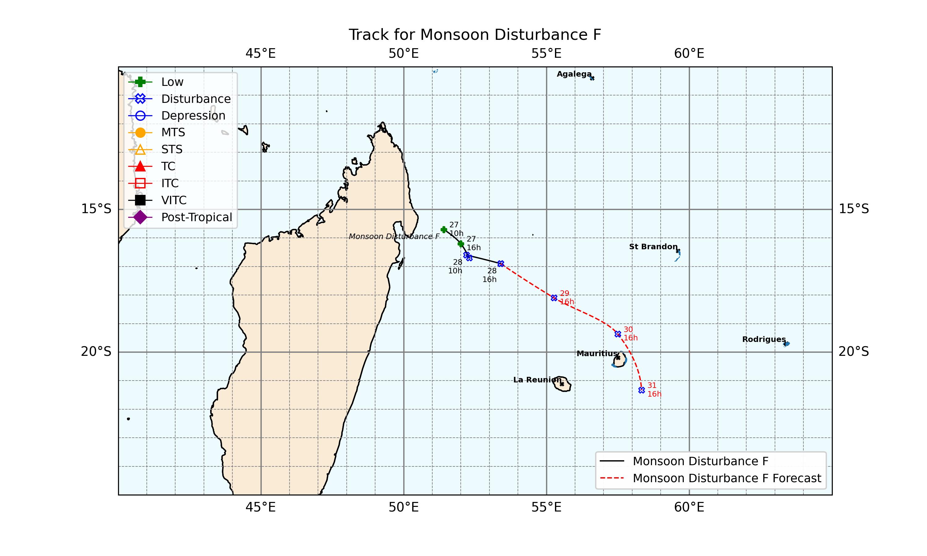
- On 27 January, Météo-France (MFR) began monitoring a broad area of low pressure situated to the east of Madagascar, designating it as Zone of Disturbed Weather 08. The disturbance brought increased cloudiness and scattered squalls to parts of Madagascar and the Mascarenes as it continued to be monitored for further organisation.[72] It dissipated over the water on 28 January, merging with a monsoon trough.[73]
- On 9 June, a low-pressure system developed off a baroclinic zone south of Madagascar within a deep upper level trough. The next day, The Joint Typhoon Warning Center marked the low as Invest 95S, observing that the low had organized into a subtropical depression, and later upgraded it to a subtropical storm.[74] MFR followed suit a day later, upgrading it to a subtropical depression as the system symmetrized, albeit it consisted of shallow convective organization.[75] Later that day, MFR stopped tracking the system, without ever naming or indexing it, citing that the risk of the system becoming a subtropical storm has ceased.[76]
Storm names
Within the South-West Indian Ocean, tropical depressions and subtropical depressions that are judged to have 10-minute sustained windspeeds of 65 km/h (40 mph) by the Regional Specialized Meteorological Centre on Réunion island, France (RSMC La Réunion) are usually assigned a name. However, it is the Sub-Regional Tropical Cyclone Advisory Centres in Mauritius and Madagascar who name the systems. The Sub-Regional Tropical Cyclone Advisory Centre (Mauritius Meteorological Services) in Mauritius names a storm if it intensifies into a moderate tropical storm between 55°E and 90°E. If instead a cyclone intensifies into a moderate tropical storm between 30°E and 55°E then the Sub-Regional Tropical Cyclone Advisory Centre (Meteo Madagascar) in Madagascar assigns the appropriate name to the storm. Storm names are taken from three pre-determined lists of names, which rotate on a triennial basis, with any names that have been used automatically removed. New names this season are: Awo, Blossom, Chenge, Dudzai, Ewetse, and Fytia, which replaced Ashley, Balita, Cheneso, Dingani, Enala, and Fabien during the 2022–23 season.[77]
|
|
If a tropical cyclone crosses 90°E into the South-West Indian basin from the Australian region basin, it will retain the name assigned to it by the Australian Bureau of Meteorology (BoM). The following storms were named in this manner.[78]
- Grant
Season effects
This table lists all of the tropical cyclones and subtropical cyclones that were monitored during the 2025–2026 South-West Indian Ocean cyclone season. Information on their intensity, duration, name, areas affected, primarily comes from RSMC La Réunion. Death and damage reports come from either press reports or the relevant national disaster management agency while the damage totals are given in 2025 or 2026 USD.
| Name | Dates | Peak intensity | Areas affected | Damage (USD) |
Deaths | Ref(s). | ||
|---|---|---|---|---|---|---|---|---|
| Category | Wind speed | Pressure | ||||||
| 01 | 16–18 July | Tropical depression | 55 km/h (35 mph) | 1000 hPa (29.53 inHg) | None | None | None | |
| Awo | 6–8 August | Moderate tropical storm | 75 km/h (45 mph) | 1000 hPa (29.53 inHg) | Agaléga | None | None | |
| Blossom | 9–12 September | Moderate tropical storm | 65 km/h (40 mph) | 1003 hPa (29.62 inHg) | None | None | None | |
| Chenge | 17–25 October | Severe tropical storm | 95 km/h (60 mph) | 985 hPa (29.09 inHg) | Chagos Archipelago, Agaléga, Seychelles, Tanzania, Kenya | Unknown | None | |
| Grant | 27 December–6 January | Intense tropical cyclone | 205 km/h (125 mph) | 940 hPa (27.76 inHg) | St. Brandon, Tromelin Island, Madagascar (After crossover) | Unknown | None | |
| Dudzai | 10–21 January | Intense tropical cyclone | 205 km/h (125 mph) | 937 hPa (27.67 inHg) | Mascarene Islands | None | None | |
| Ewetse | 19–21 January | Severe tropical storm | 95 km/h (60 mph) | 992 hPa (29.29 inHg) | Mozambique, Madagascar | Unknown | None | |
| 08 | 27–28 January | Zone of disturbed weather | 35 km/h (25 mph) | 1009 hPa (29.80 inHg) | Madagascar, Mascarene Islands | Unknown | None | |
| Fytia | 29 January–4 February | Tropical cyclone | 155 km/h (100 mph) | 960 hPa (28.35 inHg) | Mozambique, Comoros, Mayotte, Juan de Nova Island, Madagascar, Mascarene Islands | $475 million | 12 | [43][45] |
| Gezani | 4–18 February | Intense tropical cyclone | 195 km/h (120 mph) | 952 hPa (28.11 inHg) | St. Brandon, Mascarene Islands, Madagascar, Juan de Nova Island, Europa Island, Mozambique, Crozet Islands, Kerguelen Islands, Heard Island and McDonald Islands | $2 billion | 63+ | [45] |
| Horacio | 18–25 February | Intense tropical cyclone | 215 km/h (130 mph) | 947 hPa (27.96 inHg) | Chagos Archipelago, Rodrigues, Saint Paul and Amsterdam Islands | None | None | |
| 12 | 13–14 March | Tropical depression | 55 km/h (35 mph) | 1002 hPa (29.59 inHg) | Seychelles, Agaléga, Rodrigues | Unknown | None | [63] |
| Indusa | 1–5 April | Tropical cyclone | 140 km/h (85 mph) | 975 hPa (28.79 inHg) | Chagos Archipelago | None | None | |
| Juluka | 26–28 April | Subtropical storm | 75 km/h (45 mph) | 1000 hPa (29.53 inHg) | None | None | None | |
| Season aggregates | ||||||||
| 14 systems | 16 July 2025 – 11 June 2026 | 215 km/h (130 mph) | 937 hPa (27.67 inHg) | >$2.48 billion | 75+ | |||
See also

- Weather of 2025 and 2026
- List of Southern Hemisphere cyclone seasons
- Tropical cyclones in 2025 and 2026
- Atlantic hurricane seasons: 2025, 2026
- Pacific hurricane seasons: 2025, 2026
- Pacific typhoon seasons: 2025, 2026
- North Indian Ocean cyclone seasons: 2025, 2026
- 2025–26 Australian region cyclone season
- 2025–26 South Pacific cyclone season
Notes
References
- ↑ "Tendance saisonnière d'activité cyclonique dans le Sud-Ouest de l'océan Indien : Saison 2025-2026". Météo-France La Réunion. 30 October 2025. Archived from the original on 15 December 2025. Retrieved 15 December 2025.
- ↑ "Summer 2025-2026 Outlook for Mauritius and Rodrigues". Mauritius Meteorological Services. 3 November 2025.
{{cite web}}:|access-date=requires|url=(help)CS1 maint: deprecated archival service (link) - ↑ "Saison cyclonique 2025/2026 : Dudzai, intensification rapide". www.cycloneoi.com (in French). Retrieved 14 January 2026.
- ↑ "Joint Typhoon Warning Center (JTWC)". www.metoc.navy.mil. Archived from the original on 9 August 2020. Retrieved 16 July 2025.
- ↑ "CYCLONE et ACTIVITE CYCLONIQUE par Météo-France La Réunion". meteofrance.re. Archived from the original on 2 September 2020. Retrieved 16 July 2025.
- ↑ "2025 Moderate Tropical Storm UNNAMED (2025198S10090)". North Carolina Institute for Climate Studies. 19 July 2025. Retrieved 24 February 2026.
- ↑ "Dépression tropicale 2 bulletin numéro 1/2/20252026" (PDF). RSMC La Réunion. Bulletin d'analyse et de prévision cyclonique (sud-ouest océan indien) (in French). Météo-France. 7 August 2025. Retrieved 22 October 2025.
- ↑ "Mauritius Meteorological Services". metservice.intnet.mu.
- ↑ "Tropical Cyclone Tony". Bureau of Meteorology. Retrieved 30 January 2026.
- ↑ "2025 Moderate Tropical Storm AWO (2025219S07062)". North Carolina Institute for Climate Studies. 8 August 2025. Retrieved 24 February 2026.
- ↑ "Dépression se comblant (AWO) 2 bulletin numéro 2/2/20252026" (PDF). RSMC La Réunion. Bulletin d'analyse et de prévision cyclonique (sud-ouest océan indien) (in French). Météo-France. 8 August 2025. Retrieved 22 October 2025.
- ↑ "CYCLONE et ACTIVITE CYCLONIQUE par Météo-France La Réunion". meteofrance.re. Retrieved 14 September 2025.
- ↑ "2025 Moderate Tropical Storm BLOSSOM (2025252S09069)". North Carolina Institute for Climate Studies. 13 September 2025. Retrieved 24 February 2026.
- ↑ "2025 Severe Tropical Storm CHENGE (2025291S08074)". North Carolina Institute for Climate Studies. 25 October 2025. Retrieved 24 February 2026.
- ↑ RSMC La Réunion (27 December 2025). "Forte tempête tropicale 5 (Grant) bulletin numéro 1/5/20252026" (PDF). Bulletin d'analyse et de prévision cyclonique (sud-ouest océan indien) (in French). Météo-France. Retrieved 28 December 2025.
- ↑ RSMC La Réunion (28 December 2025). "Cyclone tropical 5 (Grant) bulletin numéro 5/5/20252026" (PDF). Bulletin d'analyse et de prévision cyclonique (sud-ouest océan indien) (in French). Météo-France. Retrieved 28 December 2025.
- ↑ RSMC La Réunion (28 December 2025). "Cyclone tropical intense 5 (Grant) bulletin numéro 8/5/20252026" (PDF). Bulletin d'analyse et de prévision cyclonique (sud-ouest océan indien) (in French). Météo-France. Retrieved 28 December 2025..
- ↑ "Tropical Cyclone 09S (GRANT) Warning Nr 024". Joint Typhoon Warning Center. 29 December 2025. Retrieved 29 December 2025..
- ↑ "Tropical Cyclone 09S (GRANT) Warning Nr 025". Joint Typhoon Warning Center. 29 December 2025. Retrieved 29 December 2025.
- ↑ RSMC La Réunion (31 December 2025). "Cyclone tropical 5 (Grant) bulletin numéro 18/5/20252026" (PDF). Bulletin d'analyse et de prévision cyclonique (sud-ouest océan indien) (in French). Météo-France. Retrieved 31 December 2025.
- ↑ RSMC La Réunion (1 January 2026). "Forte tempête tropicale 5 (Grant) bulletin numéro 21/5/20252026" (PDF). Bulletin d'analyse et de prévision cyclonique (sud-ouest océan indien) (in French). Météo-France. Retrieved 1 January 2026.
- ↑ RSMC La Réunion (2 January 2026). "Dépression tropicale 5 (Grant) bulletin numéro 26/5/20252026" (PDF). Bulletin d'analyse et de prévision cyclonique (sud-ouest océan indien) (in French). Météo-France. Retrieved 2 January 2026.
- ↑ "Special Weather Bulletin". Mauritius Meteorological Services. 4 January 2026. Archived from the original on 4 January 2026. Retrieved 4 January 2026.
- ↑ RSMC La Réunion (5 January 2026). "Zone perturbée 5 (Grant) bulletin numéro 31/5/20252026" (PDF). Bulletin d'analyse et de prévision cyclonique (sud-ouest océan indien) (in French). Météo-France. Retrieved 5 January 2026.
- ↑ RSMC La Réunion (10 January 2026). "Dépression tropicale 6 bulletin numéro 2/6/20252026" (PDF). Bulletin d'analyse et de prévision cyclonique (sud-ouest océan indien) (in French). Météo-France. Retrieved 10 January 2026.
- ↑ RSMC La Réunion (12 January 2026). "Cyclone tropical intense 6 (Dudzai) bulletin numéro 9/6/20252026" (PDF). Bulletin d'analyse et de prévision cyclonique (sud-ouest océan indien) (in French). Météo-France. Retrieved 12 January 2026.
- ↑ RSMC La Réunion (13 January 2026). "Cyclone tropical 6 (Dudzai) bulletin numéro 14/6/20252026" (PDF). Bulletin d'analyse et de prévision cyclonique (sud-ouest océan indien) (in French). Météo-France. Retrieved 13 January 2026.
- ↑ RSMC La Réunion (14 January 2026). "Forte tempête tropicale 6 (Dudzai) bulletin numéro 17/6/20252026" (PDF). Bulletin d'analyse et de prévision cyclonique (sud-ouest océan indien) (in French). Météo-France. Retrieved 14 January 2026..
- ↑ Réunion la 1ère (17 January 2026). "Le cyclone tropical Dudzai devrait rester à 300 kilomètres de La Réunion, Rodrigues est en alerte cyclonique 1". France Info (in French). Retrieved 17 January 2026.
{{cite news}}: CS1 maint: numeric names: authors list (link) - ↑ "Dudzai : Air Mauritius annule tous ses vols à destination et au départ de Rodrigues ce dimanche". Imaz Press Réunion (in French). 18 January 2026. Retrieved 18 January 2026.
- ↑ "Bulletin prévision - Rodrigues". Mauritius Meteorological Services (in French). 18 January 2026. Archived from the original on 18 January 2026. Retrieved 18 January 2026.
{{cite web}}: CS1 maint: bot: original URL status unknown (link) - ↑ "Tempête tropicale Dudzaï : des vagues approchant les trois mètres dans la nuit, vigilance jaune dans le Sud et Sud-Est". Le Quotidien (in French). 19 January 2026. Retrieved 19 January 2026..
- ↑ "EWETSE : 19/01/2026 to 21/01/2026". RSMC La Réunion.
- ↑ "Ewetse nearby as flooding continues in southern and central Mozambique — ActionAid". Mozambique. 21 January 2026.
- ↑ Aurélie Kouman (23 January 2026). "Le sud-ouest de Madagascar frappé par le cyclone Ewetse, un phénomène rare dans une région aride". Radio France Internationale (in French). Retrieved 29 January 2026..
- ↑ "Overall Green Tropical Cyclone alert for EWETSE-26 in Madagascar from 20 Jan 2026 00:00 UTC to 12:00". www.gdacs.org.
- ↑ "Madagascar : Ewetse déclassée au stade de dépression sur terre, le système s'affaiblit". imazpress.com. 21 January 2026.
- ↑ "Zone of Disturbed Weather Nr 1/9/20252026" (PDF). RSMC La Réunion. TROPICAL CYCLONE FORECAST WARNING (SOUTH-WEST INDIAN OCEAN). Météo-France. 28 January 2026. Retrieved 28 January 2026.
- ↑ "TROPICAL CYCLONE 9 (FYTIA) WARNING NUMBER: 10/9/20252026" (PDF). Météo-France La Réunion. 31 January 2026. Retrieved 31 January 2026.
- ↑ "FYTIA : 28/01/2026 TO 31/01/2026". Météo-France La Réunion. 31 January 2026. Retrieved 31 January 2026.
- ↑ RCMS La Réunion (31 January 2026). "Cyclone tropical 9 (Fytia) bulletin numéro 10/9/20252026" (PDF). Bulletin d'analyse et de prévision cyclonique (sud-ouest océan indien) (in French). Météo-France. Retrieved 31 January 2026.
- ↑ Rowlands, Lyndal (11 February 2026). "'Monstrous': Cyclone Gezani hits Madagascar, leaving at least 31 dead". Al Jazeera. Retrieved 7 April 2026.
- 1 2 "Cyclone : Le bilan humain du passage de Fytia s'élève à 12 décès". 2424.mg. Nouvelles (in French). 4 February 2026. Retrieved 4 February 2026.
- 1 2 Lörinc, Michal; Hotový, Ondřej; Elizondo, Antonio; Čejka, Tomáš; Chug, Divyansh (16 April 2026). "Global Catastrophe Recap First Quarter (Q1) of 2026" (PDF). aon.com. Retrieved 16 April 2026.
- 1 2 3 4 "L'impact financier combiné des cyclones Fytia et Gezani estimé par le Gouvernement à plus de 2,47 milliards de dollars". 2424.mg (in French). 6 March 2026. Retrieved 27 April 2026..
- ↑ "Mauritius Meteorological Services". metservice.intnet.mu.
- ↑ "CYCLONE et ACTIVITE CYCLONIQUE par Météo-France La Réunion". meteofrance.re.
- ↑ "Cyclone Gezani makes landfall on Madagascar as a Category 3 storm". cimss.ssec.wisc.edu. 10 February 2026. Retrieved 11 February 2026.
- ↑ "At least 9 dead in Madagascar as Tropical Cyclone Gezani hits the Indian Ocean island". NewsNation. 11 February 2026. Retrieved 11 February 2026.
- ↑ "Death toll rises to 20 as Cyclone Gezani strikes Madagascar's east coast". Anadolu Agency. 11 February 2026. Retrieved 11 February 2026.
- ↑ "Death toll in Madagascar cyclone rises to 35". AP News. 12 February 2026. Retrieved 12 February 2026.
- ↑ "Cyclone kills 20 in Madagascar as 2nd-largest city '75% destroyed'". France 24. 11 February 2026. Retrieved 11 February 2026.
- ↑ "TROPICAL CYCLONE 22S (HORACIO) WARNING NR 001". Joint Typhoon Warning Center. 19 February 2026. Retrieved 25 February 2026.
- ↑ "2026 Moderate Tropical Storm HORACIO (2026051S15076)". North Carolina Institute for Climate Studies. 22 February 2026. Retrieved 24 February 2026.
- ↑ RSMC La Réunion (23 February 2026). "Cyclone tropical intense 11 (Horacio) bulletin numéro 19/11/20252026" (PDF). Bulletin d'analyse et de prévision cyclonique (sud-ouest océan indien) (in French). Météo-France. Retrieved 23 February 2026.
- ↑ Jeff Masters (23 February 2026). "Tropical Cyclone Horacio: Earth's first Category 5 tropical cyclone of 2026". Yale Climate Connections. Retrieved 23 February 2026.
- ↑ "Tropical Cyclone 22S (HORACIO) Warning NR 009". Joint Typhoon Warning Center. 23 February 2026. Archived from the original on 24 February 2026. Retrieved 23 February 2026.
- ↑ "TROPICAL CYCLONE 22S (HORACIO) WARNING NR 010". Joint Typhoon Warning Center. 24 February 2026. Archived from the original on 24 February 2026. Retrieved 24 February 2026.
- ↑ RSMC La Réunion (3 March 2026). "HORACIO : 17/02/2026 to 03/03/2026". Météo-France. Retrieved 6 March 2026.
- ↑ CMRS La Réunion (14 March 2026). "Dépression tropicale 12 bulletin numéro 4/12/20252026" (PDF). Météo-France. Bulletin d'analyse et de prévision cyclonique (sud-ouest océan indien) (in French). Retrieved 14 March 2026.
- ↑ CMRS La Réunion (14 March 2026). "Zone perturbée 12 bulletin numéro 5/12/20252026" (PDF). Météo-France. Bulletin d'analyse et de prévision cyclonique (sud-ouest océan indien) (in French). Retrieved 14 March 2026.
- ↑ "SUBJ/SIGNIFICANT TROPICAL WEATHER ADVISORY FOR THE INDIAN OCEAN REISSUED/150600Z-151800ZMAR2026". JTWC. 14 March 2026. Retrieved 17 March 2026.
- 1 2 3 "Changement climatique — Rodrigues : du jamais-vu avec +100 mm de pluie en 12h". Le Mauricien (in French). 16 March 2026. Retrieved 16 March 2026.
- ↑ RSMC La Réunion (1 April 2026). "Zone perturbée 13 bulletin numéro 1/13/20252026" (PDF). Bulletin d'analyse et de prévision cyclonique (sud-ouest océan indien) (in French). Météo-France. Retrieved 1 April 2026.
- ↑ "Subj/Significant Tropical Weather Advisory for the Indian Ocean/291800Z-301800ZMAR2026". Joint Typhoon Warning Center. 29 March 2026. Retrieved 1 April 2026.
- ↑ RSMC La Réunion (2 April 2026). "Tempête tropicale modérée 13 (Indusa) bulletin numéro 4/13/20252026" (PDF). Bulletin d'analyse et de prévision cyclonique (sud-ouest océan indien) (in French). Météo-France. Retrieved 2 April 2026.
- ↑ RSMC La Réunion (5 April 2026). "INDUSA : 29/03/2026 TO 05/04/2026". Trajectories. Météo-France. Retrieved 5 April 2026.
- ↑ RSMC La Réunion (5 April 2026). "Dépression post-tropicale 13 (Indusa) bulletin numéro 17/13/20252026" (PDF). Bulletin d'analyse et de prévision cyclonique (sud-ouest océan indien) (in French). Météo-France. Retrieved 5 April 2026.
- ↑ "Subtropical Storm Juluka Warning Number: 1/14/20252026" (PDF). Météo-France La Reunion. 27 April 2026. Archived from the original (PDF) on 10 June 2026.
- ↑ "Juluka dans le Sud-Sud Ouest Maurice". Maurice Info. 27 April 2026. Archived from the original on 30 April 2026.
- ↑ "Bulletin sur l'activité cyclonique et les conditions météorologiques tropicales sur le sud-ouest de l'océan Indien le 08/01/2026 à 1200 UTC" (PDF). RSMC La Réunion (in French). Météo-France. 8 January 2026. Retrieved 8 January 2026.
- ↑ "Track for Monsoon Disturbance F" (JPG). metservice.intnet.mu.
- ↑ "0820252026 : 26/01/2026 TO 28/01/2026". RSMC La Réunion. Météo-France. 28 January 2026. Retrieved 29 January 2026.
- ↑ "ABIO10 PGTW 110200 - SIGNIFICANT TROPICAL WEATHER ADVISORY FOR THE INDIAN OCEAN". Naval Meteorology and Oceanography Command. Archived from the original on 11 June 2026. Retrieved 11 June 2026.
- ↑ "BULLETIN FOR CYCLONIC ACTIVITY AND SIGNIFICANT TROPICAL WEATHER" (PDF). Météo-France La Réunion. Archived from the original (PDF) on 11 June 2026.
- ↑ "CYCLONE et ACTIVITE CYCLONIQUE par Météo-France La Réunion". METEO FRANCE LA RÉUNION par Météo-France (in French). Retrieved 11 June 2026.
- ↑ RA I Tropical Cyclone Committee (2023). Tropical Cyclone Operational Plan for the South-West Indian Ocean (PDF) (Report). World Meteorological Organization. Archived from the original (PDF) on 2 July 2024.
- ↑ Tropical cyclone names (Report). Australian Bureau of Meteorology. Archived from the original on 26 December 2022. Retrieved 26 December 2022.
External links

- Météo-France La Réunion (in French)
- Direction Générale de la Météorologie de Madagascar (in French)
- Mauritius Meteorological Services
- Joint Typhoon Warning Center (JTWC) Archived 9 August 2020 at the Wayback Machine